Approximate Location Map
Large Map »
Latitude: 50.201 / 50°12'3"N
Longitude: -5.3199 / 5°19'11"W
OS Eastings: 163179
OS Northings: 38714
OS Grid: SW631387
Mapcode National: GBR FX74.XML
Mapcode Global: VH12P.Q6YS
Plus Code: 9C2P6M2J+92
Entry Name: Clapper Bridge
Listing Date: 12 September 1989
Grade: II
Source: Historic England
Source ID: 1142667
English Heritage Legacy ID: 66611
ID on this website: 101142667
Location: Barripper, Cornwall, TR14
County: Cornwall
Civil Parish: Camborne
Traditional County: Cornwall
Lieutenancy Area (Ceremonial County): Cornwall
Church of England Parish: Penponds
Church of England Diocese: Truro
Tagged with: Bridge
CAMBORNE MILL ROAD
SW 63 NW
(off west end)
7/65 Barripper
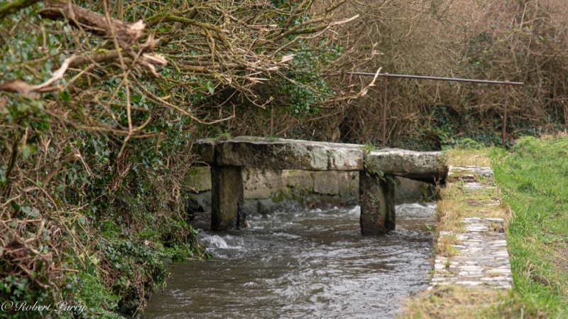
Clapper bridge
II
Public footbridge over stream. Probably early C18 or earlier. Granite.
Clapper bridge type, with 3 flat spans formed by roughly-hewn stone planks
in pairs tied together with iron staples and supported by 2 hefty blocks set
in the bed of the stream. On the south side is a simple iron handrail
supported by 4 very slender iron posts. A rare survival.
Listing NGR: SW6317938714
External links are from the relevant listing authority and, where applicable, Wikidata. Wikidata IDs may be related buildings as well as this specific building. If you want to add or update a link, you will need to do so by editing the Wikidata entry.


Other nearby listed buildings
