Approximate Location Map
Large Map »
Latitude: 54.6634 / 54°39'48"N
Longitude: -2.7515 / 2°45'5"W
OS Eastings: 351624
OS Northings: 530077
OS Grid: NY516300
Mapcode National: GBR 9G7J.32
Mapcode Global: WH81B.P1ZR
Plus Code: 9C6VM67X+9C
Entry Name: 46, King Street
Listing Date: 26 July 1982
Grade: II
Source: Historic England
Source ID: 1145075
English Heritage Legacy ID: 72887
ID on this website: 101145075
Location: Penrith, Westmorland and Furness, Cumbria, CA11
County: Cumbria
District: Eden
Civil Parish: Penrith
Built-Up Area: Penrith
Traditional County: Cumberland
Lieutenancy Area (Ceremonial County): Cumbria
Church of England Parish: Penrith St Andrew
Church of England Diocese: Carlisle
Tagged with: Building
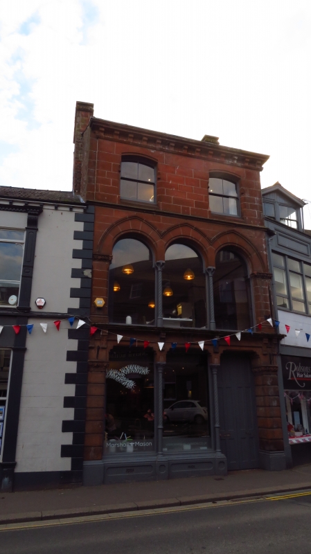
1.
5165 KING STREET
(west side)
No 46
NY 5130 1/128 26.7.82
II GV
2.
Mid C19. Red sandstone. Ashlar with slate roof. Three storeys. Original
3 bay shop front on cast iron columns supporting a flat head on ground floor
and arched on first with continuous Gothic dip mould. Two plain sashes with
segmental heads on second floor. Modillion eaves cornice. Ashlar end stacks.
Listing NGR: NY5161730071
External links are from the relevant listing authority and, where applicable, Wikidata. Wikidata IDs may be related buildings as well as this specific building. If you want to add or update a link, you will need to do so by editing the Wikidata entry.


Other nearby listed buildings
