Approximate Location Map
Large Map »
Latitude: 54.4858 / 54°29'8"N
Longitude: -0.615 / 0°36'53"W
OS Eastings: 489823
OS Northings: 510934
OS Grid: NZ898109
Mapcode National: GBR SJ4K.NQ
Mapcode Global: WHG9Y.JHCY
Plus Code: 9C6XF9PP+82
Entry Name: 23, Baxtergate
Listing Date: 23 February 1954
Grade: II
Source: Historic England
Source ID: 1148344
English Heritage Legacy ID: 326537
ID on this website: 101148344
Location: Whitby, North Yorkshire, YO21
County: North Yorkshire
District: Scarborough
Civil Parish: Whitby
Built-Up Area: Whitby
Traditional County: Yorkshire
Lieutenancy Area (Ceremonial County): North Yorkshire
Church of England Parish: Whitby St Mary
Church of England Diocese: York
Tagged with: Building
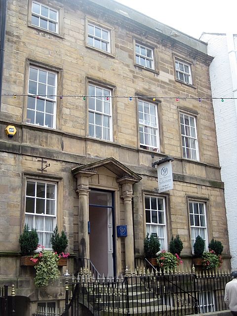
1,
1811 BAXTERGATE
(South Side)
No 23
NZ 8910 3/53 23.2.54.
II
2.
3rd quarter of C18. 3 storeys in ashlar, 4 double hung sash windows in
moulded architraves, those on ground and 1st floor with aprons. Dentilled
cornice and parapet. Doric columns to open-pedimented doorway, triglyph
frieze, rectangular fanlight, 6-fielded door in architrave. NMR.
Listing NGR: NZ8982310934
External links are from the relevant listing authority and, where applicable, Wikidata. Wikidata IDs may be related buildings as well as this specific building. If you want to add or update a link, you will need to do so by editing the Wikidata entry.


Other nearby listed buildings
