Approximate Location Map
Large Map »
Latitude: 54.1756 / 54°10'32"N
Longitude: -1.2565 / 1°15'23"W
OS Eastings: 448631
OS Northings: 475789
OS Grid: SE486757
Mapcode National: GBR MNN4.SX
Mapcode Global: WHD8X.N9WR
Plus Code: 9C6W5PGV+6C
Entry Name: Church of St Mary
Listing Date: 20 June 1966
Grade: II
Source: Historic England
Source ID: 1150720
English Heritage Legacy ID: 332859
ID on this website: 101150720
Location: St Mary's Church, Birdforth, North Yorkshire, YO61
County: North Yorkshire
District: Hambleton
Civil Parish: Birdforth
Traditional County: Yorkshire
Lieutenancy Area (Ceremonial County): North Yorkshire
Church of England Parish: Husthwaite St Nicholas
Church of England Diocese: York
Tagged with: Church building
BIRDFORTH A19
SE 47 NE
(east side, off)
4/1 Church of St Mary
20.6.66
- II
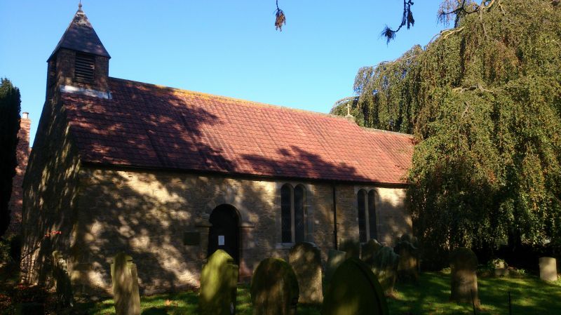
Redundant church. C12, C16-C17, C18 and C19. Rubblestone with interlocking tile
roof. 4-bay nave, single-cell chancel. Quoins. Nave: quoined round-arched south
door with imposts, the right half restored; to its right two windows, each of 2
round-arched lights; at west end C19 brick belfry with louvred bell-openings and
pyramidal Welsh slate roof with iron finial; east gable cross. On north side a
later window at east end. In west end a small segment-arched window. Chancel,
lower and narrower, has traces of former opening on left, east gable cross, and
east window as nave. Interior: round chancel arch with imposts; 4 principal rafter
roof trusses with curved collars to nave, the tie-beams with groove-moulding and
one with sunk panel containing letters and date 'G1702B' below motif; in chancel
north wall, architraved sunken panel with embossed shield and flowers and letters
and date '1585':
I T
A S(?). c1700 pulpit, panelled with vine-trail and simpler top mouldings,
knob finials to gate posts and lectern with brass candlestick; lectern with turned
C17 baluster-like shaft on renewed base; C12 circular tub font on renewed base with
probably C17 cover having ogee-shaped ribs; in chancel, chamfered stone top of
probably C14 tomb with incised sword.
Listing NGR: SE4863175789
External links are from the relevant listing authority and, where applicable, Wikidata. Wikidata IDs may be related buildings as well as this specific building. If you want to add or update a link, you will need to do so by editing the Wikidata entry.


Other nearby listed buildings
