Approximate Location Map
Large Map »
Latitude: 53.5195 / 53°31'10"N
Longitude: -1.5986 / 1°35'54"W
OS Eastings: 426712
OS Northings: 402615
OS Grid: SE267026
Mapcode National: GBR KW8R.Q2
Mapcode Global: WHCBQ.FS0Q
Plus Code: 9C5WGC92+RH
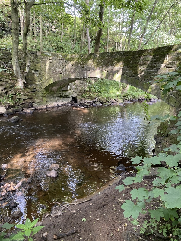
Entry Name: Willow Bridge, Approximately 300 Metres North of Willow Lane Bungalow
Listing Date: 27 April 1988
Grade: II
Source: Historic England
Source ID: 1151024
English Heritage Legacy ID: 334027
ID on this website: 101151024
Location: Oxspring, Barnsley, South Yorkshire, S36
County: Barnsley
Civil Parish: Oxspring
Built-Up Area: Penistone
Traditional County: Yorkshire
Lieutenancy Area (Ceremonial County): South Yorkshire
Church of England Parish: Penistone St John the Baptist
Church of England Diocese: Sheffield
Tagged with: Architectural structure Packhorse bridge
4/2 OXSPRING SHEFFIELD ROAD,
SE20SE SE2670 0260
(north side, off)
4/2 Willow Bridge,
approx. 300 metres
north of
Willow Lane Bungalow
II
Packhorse bridge. Probably C17. Coursed, squared rubble, ashlar voussoirs
and springing. Single span, narrow bridge over the River Don with slightly
pointed arch. Parapets and copings. Tarmac walkway. Two ribs support the
arch.
Listing NGR: SE2671202615
External links are from the relevant listing authority and, where applicable, Wikidata. Wikidata IDs may be related buildings as well as this specific building. If you want to add or update a link, you will need to do so by editing the Wikidata entry.


Other nearby listed buildings
