Approximate Location Map
Large Map »
Latitude: 53.2241 / 53°13'26"N
Longitude: -1.0762 / 1°4'34"W
OS Eastings: 461774
OS Northings: 370066
OS Grid: SK617700
Mapcode National: GBR 9FP.YJ2
Mapcode Global: WHFGS.F7R6
Plus Code: 9C5W6WFF+JG
Entry Name: Woodland View
Listing Date: 11 August 1961
Last Amended: 20 June 1986
Grade: II
Source: Historic England
Source ID: 1157042
English Heritage Legacy ID: 242233
ID on this website: 101157042
Location: Budby, Newark and Sherwood, Nottinghamshire, NG22
County: Nottinghamshire
District: Newark and Sherwood
Civil Parish: Perlethorpe cum Budby
Traditional County: Nottinghamshire
Lieutenancy Area (Ceremonial County): Nottinghamshire
Church of England Parish: Edwinstowe
Church of England Diocese: Southwell and Nottingham
Tagged with: Building
PERLETHORPE THE LANE
SK 67 SW
CUM BUDBY (north side)
1/91 Woodland View
(formerly listed
as Cottage facing
War Memorial on
green on corner of
11.8.61 road)
G.V. II
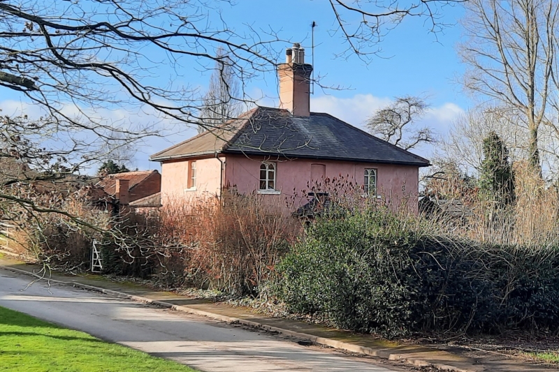
Estate cottage and adjoining outbuilding. Early Cl9. Brick,
rendered, with hipped slate roof. Stone plinth. Single
central ridge stack. 2 storeys, 3 bays. Square plan. Some
Gothick casements. East front has central hipped brick porch
with recessed central bay flanked by square piers. Single tiny
casement. To south, door with moulded surround. Flanked by
single casements, that to right Gothick. Above, central blank
window flanked by single smaller casements. North front has off-
centre door. Above, to left, a Yorkshire sash. To right, C20
casement. West end has hipped lean-to addition, with door and
C20 casement. South side has 2 casements and above, a casement
to right. To west, adjoining single storey outbuilding, late
C19, brick with pantile roof. Single side wall stack. To north,
2 doors. To west, C20 garage door. To east, barred Yorkshire
sash with segmental head, and adjoining toilet block. This
building is part of the complete Estate Village laid out by Earl
Manvers of Thoresby Park 1807-1812.
Listing NGR: SK6177470066
External links are from the relevant listing authority and, where applicable, Wikidata. Wikidata IDs may be related buildings as well as this specific building. If you want to add or update a link, you will need to do so by editing the Wikidata entry.


Other nearby listed buildings
