Approximate Location Map
Large Map »
Latitude: 51.9296 / 51°55'46"N
Longitude: -0.561 / 0°33'39"W
OS Eastings: 499042
OS Northings: 226652
OS Grid: SP990266
Mapcode National: GBR F31.WJP
Mapcode Global: VHFR5.7R9N
Plus Code: 9C3XWCHQ+RJ
Entry Name: Tithe Farmhouse
Listing Date: 26 September 1980
Grade: II
Source: Historic England
Source ID: 1158330
English Heritage Legacy ID: 35917
ID on this website: 101158330
Location: Tebworth, Central Bedfordshire, LU7
County: Central Bedfordshire
Civil Parish: Chalgrave
Built-Up Area: Tebworth
Traditional County: Bedfordshire
Lieutenancy Area (Ceremonial County): Bedfordshire
Church of England Parish: Chalgrave
Church of England Diocese: St.Albans
Tagged with: Farmhouse
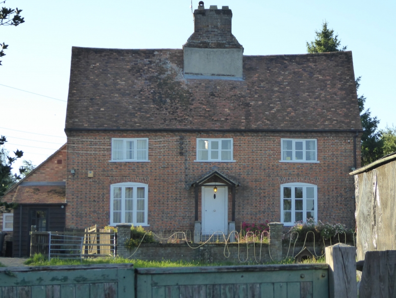
1.
5125 CHALGRAVE WINGFIELD ROAD
(west side)
Tebworth
Tithe Farmhouse
SP 9926 15/69
II
2.
Late C17 or early C18. Chequered red and vitrified brick. Two storeys. Old clay
tile roof. Brick modillion eaves. Three casements. C19 porch. Large central
brick chimney stack.
Listing NGR: SP9904226652
External links are from the relevant listing authority and, where applicable, Wikidata. Wikidata IDs may be related buildings as well as this specific building. If you want to add or update a link, you will need to do so by editing the Wikidata entry.


Other nearby listed buildings
