Approximate Location Map
Large Map »
Latitude: 51.9293 / 51°55'45"N
Longitude: -0.584 / 0°35'2"W
OS Eastings: 497456
OS Northings: 226587
OS Grid: SP974265
Mapcode National: GBR F36.34F
Mapcode Global: VHFR4.TRLW
Plus Code: 9C3XWCH8+P9
Entry Name: Gable End
Listing Date: 7 March 1979
Grade: II
Source: Historic England
Source ID: 1158683
English Heritage Legacy ID: 35997
ID on this website: 101158683
Location: Hockliffe, Central Bedfordshire, LU7
County: Central Bedfordshire
Civil Parish: Hockliffe
Built-Up Area: Hockliffe
Traditional County: Bedfordshire
Lieutenancy Area (Ceremonial County): Bedfordshire
Church of England Parish: Hockliffe
Church of England Diocese: St.Albans
Tagged with: Architectural structure
1.
5125
SP 9726
13/170
7.3.79
HOCKLIFFE
WATLING STREET
(south-west side)
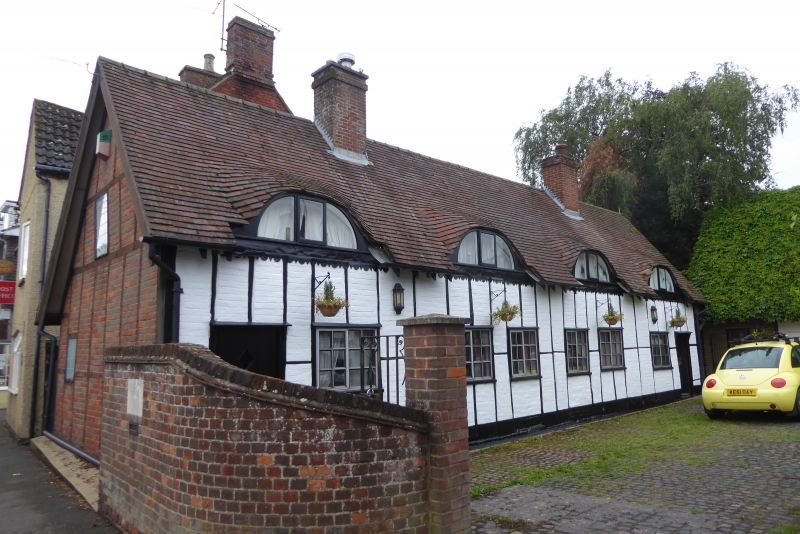
Gable End, The Square
II
2.
C17. Timber-framed, with whitewashed brick nogging. One storey and attics. Corrugated
iron roof. Four eyebrow dormers to north elevation and 5 casements to ground floor.
Gable end to road.
Listing NGR: SP9745626587
External links are from the relevant listing authority and, where applicable, Wikidata. Wikidata IDs may be related buildings as well as this specific building. If you want to add or update a link, you will need to do so by editing the Wikidata entry.


Other nearby listed buildings
