Approximate Location Map
Large Map »
Latitude: 52.2137 / 52°12'49"N
Longitude: -0.5035 / 0°30'12"W
OS Eastings: 502341
OS Northings: 258330
OS Grid: TL023583
Mapcode National: GBR G14.5JD
Mapcode Global: VHFPV.7M5B
Plus Code: 9C4X6F7W+FH
Entry Name: Church of St Mary the Virgin
Listing Date: 13 July 1964
Grade: II*
Source: Historic England
Source ID: 1158715
English Heritage Legacy ID: 36821
ID on this website: 101158715
Location: St Mary's Church, Bletsoe, Bedford, Bedfordshire, MK44
County: Bedford
Civil Parish: Bletsoe
Traditional County: Bedfordshire
Lieutenancy Area (Ceremonial County): Bedfordshire
Church of England Parish: Bletsoe
Church of England Diocese: St.Albans
Tagged with: Church building
BLETSOE THE AVENUE
TL 05NW (East Side)
6/35 Church of St Mary the
Virgin
13.7.64
- II*
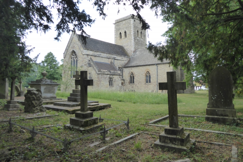
Medieval parish church, much restored in mid C19. Coursed limestone rubble.
Irregular cruciform plan with central tower, whose form suggests Saxo-Norman
origins, though details at top, corner gargoyles and double trefoiled lights
in each side, are C14. The chancel is a C19 restoration of a C14 rebuilding.
It has two arched tomb recesses and is derelict, being bricked off from the
tower. The roofless vestry to the north is a C19 rebuilding. The north
transept overlaps both tower and chancel: approached from the tower, it is a
C19 renovation of the St John Chapel, and contains a wall memorial to Frances
Countess Bolingbroke d. 1678. The south transept, C14 restored, is slightly
askew to the axis of the tower. The aisleless nave, heavily restored but
probably of late C13 origins, now contains the Sir John St John (d. 1559)
memorial, moved in 1978 from the north transept. It is in alabaster and shows
his family under a canopy supported by columns. There is a C19 rebuilt porch
to the south of the nave, which has diagonal corner buttresses at its west
end. The octagonal font is C15.
Listing NGR: TL0234158330
External links are from the relevant listing authority and, where applicable, Wikidata. Wikidata IDs may be related buildings as well as this specific building. If you want to add or update a link, you will need to do so by editing the Wikidata entry.


Other nearby listed buildings
