Approximate Location Map
Large Map »
Latitude: 54.7791 / 54°46'44"N
Longitude: -1.5818 / 1°34'54"W
OS Eastings: 426996
OS Northings: 542763
OS Grid: NZ269427
Mapcode National: GBR KFD5.BM
Mapcode Global: WHC4Q.N4YM
Plus Code: 9C6WQCH9+J7
Entry Name: Durham Railway Station Front Range
Listing Date: 10 March 1988
Grade: II
Source: Historic England
Source ID: 1161508
English Heritage Legacy ID: 110520
ID on this website: 101161508
Location: Durham, County Durham, DH1
County: County Durham
Electoral Ward/Division: Elvet and Gilesgate
Parish: City of Durham
Built-Up Area: Durham
Traditional County: Durham
Lieutenancy Area (Ceremonial County): County Durham
Church of England Parish: Durham St Cuthbert
Church of England Diocese: Durham
Tagged with: Architectural structure
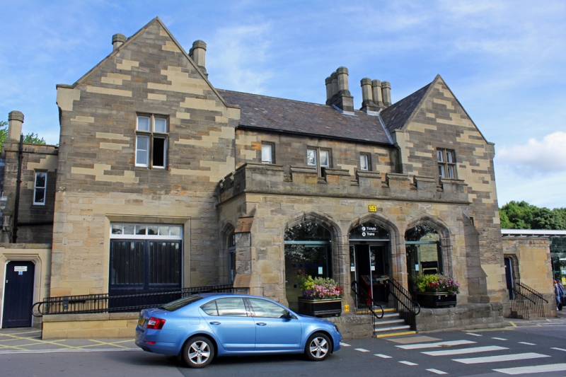
DURHAM AND FRAMWELLGATE STATION APPROACH
NZ 24 SE and NZ 2742 NW (North end)
4 and 9/462 Durham Railway Station
front range
GV II
Railway station. 1857, probably by G.T. Andrews for North Eastern Railway Company.
Coursed squared sandstone with ashlar dressings; Welsh slate roof with stone
gable copings. Main block H-plan; extension to left, including former water
tower; short extension to right. Tudor Gothic style.
Main block: 2 storeys, 5 bays; 3-bay central portico has double-chamfered Tudor
arches on plinth, with steps up to the central arch; diagonal buttresses and
battlemented parapet. Renewed doors at centre and right have overlights, the
right stone-mullioned over shouldered door; cross window in left bay. Stone
mullions and transoms to windows of 1 and 2 lights above. Gabled end bays contain
wide loading door at left and cross window at right on ground floor; stone cross
windows above; label moulds to windows in gabled bays. Steeply-pitched roof of
fishscale pattern; sloped copings resting on moulded kneelers; truncated polygonal
chimneys. Left extension has one-storey 3-bay link (with casements and steeply-
pitched roof) to battlemented tower on blocked arcade. Small outbuilding to
left of main block has shouldered surround to door in right return; sloped coping
to wall. One-storey one-bay right extension in similar style.
Listing NGR: NZ2699642763
External links are from the relevant listing authority and, where applicable, Wikidata. Wikidata IDs may be related buildings as well as this specific building. If you want to add or update a link, you will need to do so by editing the Wikidata entry.


Other nearby listed buildings
