Approximate Location Map
Large Map »
Latitude: 50.2581 / 50°15'29"N
Longitude: -5.2596 / 5°15'34"W
OS Eastings: 167761
OS Northings: 44874
OS Grid: SW677448
Mapcode National: GBR Z2.0TQB
Mapcode Global: VH12B.SSB0
Plus Code: 9C2P7P5R+65
Entry Name: Laity Farmhouse
Listing Date: 12 September 1989
Grade: II
Source: Historic England
Source ID: 1161558
English Heritage Legacy ID: 66798
ID on this website: 101161558
Location: Cornwall, TR16
County: Cornwall
Civil Parish: Redruth
Traditional County: Cornwall
Lieutenancy Area (Ceremonial County): Cornwall
Church of England Parish: Saint Illogan
Church of England Diocese: Truro
Tagged with: Farmhouse
REDRUTH BRIDGE
SW 64 SE
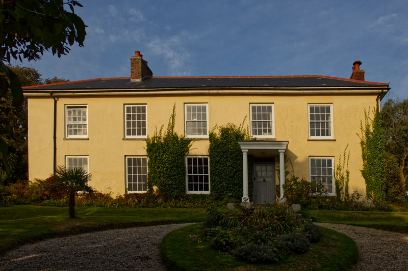
5/244 Laity Farmhouse
II
Farmhouse. Probably earlier C19, but probably with earlier core. Render,
probably on uncoursed rubble, with granite plinth, slurried slate roof,
brick chimneys. Rectangular double-depth plan. Two storeys and 5 bays,
raised on a low plinth; doorway in 4th bay, up 5 wide steps, with plain
reveal, recessed boarded and glazed door and shallow 4-pane overlight; 4
windows on each floor, all 16-pane sashes with plain reveals and raised
sills. Hipped roof with projecting eaves, a ridge chimney between the 1st
and 2nd bays and a gable chimney to the right. Interior: axial chimney
stack approx. 2½ metres thick, with very large back-to-back fireplaces (now
concealed); dog-legged staircase with open string, scrolled brackets, stick
balusters, and mahogany handrail with wreathed curtail.
Listing NGR: SW6776144874
External links are from the relevant listing authority and, where applicable, Wikidata. Wikidata IDs may be related buildings as well as this specific building. If you want to add or update a link, you will need to do so by editing the Wikidata entry.


Other nearby listed buildings
