Approximate Location Map
Large Map »
Latitude: 51.7968 / 51°47'48"N
Longitude: -2.0497 / 2°2'58"W
OS Eastings: 396670
OS Northings: 210903
OS Grid: SO966109
Mapcode National: GBR 2NJ.BM9
Mapcode Global: VHB29.F38F
Plus Code: 9C3VQXW2+P4
Entry Name: Combend Farmhouse
Listing Date: 24 June 1985
Grade: II
Source: Historic England
Source ID: 1172154
English Heritage Legacy ID: 127214
ID on this website: 101172154
Location: Cotswold, Gloucestershire, GL53
County: Gloucestershire
District: Cotswold
Civil Parish: Elkstone
Traditional County: Gloucestershire
Lieutenancy Area (Ceremonial County): Gloucestershire
Church of England Parish: Elkstone St John the Evangelist
Church of England Diocese: Gloucester
Tagged with: Farmhouse
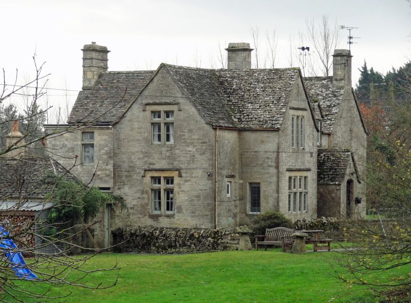
SO 91 SE ELKSTONE BEECHPIKE
3/114 Combend Farmhouse
II
Detached house. Mid C19 with addition, probably by Sidney
Barnsley, of c1920. Coursed and squared limestone; ashlar
dressings; stone slate roof. 2-storey with cross-wing to left of
entrance hall; 1 room addition to right. Front: 2 gables, 1 to
left of porch projecting with single-window fenestration; 8-light
mullioned and transomed with drip stone over and 3-light chamfered
mullioned above, also with drip stone; gabled porch with Tudor-
arched doorway and 4-panel door; floral vent in gable; small half
dormer over with timber casement; gable chimney stack to right
with stone slate weathering; leaded casements to all windows.
South-west gable end has single window fenestration: 4-light
chamfered mullioned to ground floor with 3-light over and attic
slit vent; similar gable at west end of rear elevation. Half
dormer at rear lines through with that at front arid has 3-light
below. Projecting wing at back has blank end with ridge mounted
chimney with moulded cap; 2 cross windows, 1 to each floor on west
side of wing; similar fenestration to east gable end. C20 flat
roofed addition in angle at rear.
Listing NGR: SO9667010903
External links are from the relevant listing authority and, where applicable, Wikidata. Wikidata IDs may be related buildings as well as this specific building. If you want to add or update a link, you will need to do so by editing the Wikidata entry.


Other nearby listed buildings
