Approximate Location Map
Large Map »
Latitude: 51.0696 / 51°4'10"N
Longitude: -1.3148 / 1°18'53"W
OS Eastings: 448108
OS Northings: 130253
OS Grid: SU481302
Mapcode National: GBR 85V.Y4D
Mapcode Global: FRA 8649.7LY
Plus Code: 9C3W3M9P+R3
Entry Name: The Vicarage
Listing Date: 14 January 1974
Grade: II
Source: Historic England
Source ID: 1172862
English Heritage Legacy ID: 144645
ID on this website: 101172862
Location: Hyde, Winchester, Hampshire, SO23
County: Hampshire
District: Winchester
Electoral Ward/Division: St Bartholomew
Parish: Non Civil Parish
Built-Up Area: Winchester
Traditional County: Hampshire
Lieutenancy Area (Ceremonial County): Hampshire
Church of England Parish: Winchester, Hyde St Bartholomew
Church of England Diocese: Winchester
Tagged with: Clergy house
1.
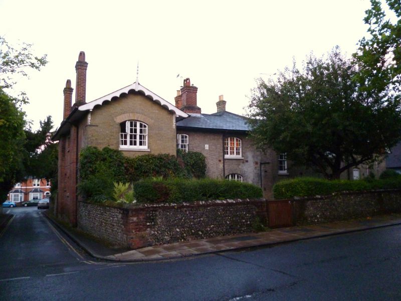
1833 HYDE STREET
(East Side)
No 54
(The Vicarage)
SU 4830 SW 1/375
II GV
2.
Dated 1835. White brick. Two storeys, five bays, the end bays projecting
with bargeboarded gables. Tripartite sash windows. Slate roof. Late
C19 tile hung gable on right.
The listed buildings from No 32 to No 60 form a group.
Listing NGR: SU4810930261
External links are from the relevant listing authority and, where applicable, Wikidata. Wikidata IDs may be related buildings as well as this specific building. If you want to add or update a link, you will need to do so by editing the Wikidata entry.


Other nearby listed buildings
