Approximate Location Map
Large Map »
Latitude: 51.1838 / 51°11'1"N
Longitude: -3.4442 / 3°26'39"W
OS Eastings: 299156
OS Northings: 143718
OS Grid: SS991437
Mapcode National: GBR LK.5R89
Mapcode Global: VH6GM.8H1W
Plus Code: 9C3R5HM4+G8
Entry Name: The Crooked Window
Listing Date: 22 May 1969
Grade: II
Source: Historic England
Source ID: 1173408
English Heritage Legacy ID: 264685
ID on this website: 101173408
Location: Dunster, Somerset, TA24
County: Somerset
District: Somerset West and Taunton
Civil Parish: Dunster
Built-Up Area: Dunster
Traditional County: Somerset
Lieutenancy Area (Ceremonial County): Somerset
Tagged with: Architectural structure
1.
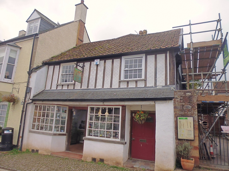
5366 DUNSTER HIGH STREET
(West Side)
No 7 (The Crooked Window)
SS 9843-9943 4/53 22.5.69
II GV
2.
Probably 18th century with later alterations. Pantile roof, render, mock half-
timbering to 1st floor. Two storeys. Two windows, sashes with glazing bars,
exposed frames. Ground floor has two fixed-light square bays with small panelled
½-glazed door between, plain recessed door to right-hand. Slated pent over doors and
bays.
Listing NGR: SS9915843714
External links are from the relevant listing authority and, where applicable, Wikidata. Wikidata IDs may be related buildings as well as this specific building. If you want to add or update a link, you will need to do so by editing the Wikidata entry.


Other nearby listed buildings
