Approximate Location Map
Large Map »
Latitude: 52.6697 / 52°40'10"N
Longitude: -0.7281 / 0°43'41"W
OS Eastings: 486106
OS Northings: 308756
OS Grid: SK861087
Mapcode National: GBR CRL.NR6
Mapcode Global: WHFKN.S5H5
Plus Code: 9C4XM79C+VQ
Entry Name: 15 and 17, High Street
Listing Date: 24 November 1971
Grade: II
Source: Historic England
Source ID: 1177764
English Heritage Legacy ID: 186484
ID on this website: 101177764
Location: Oakham, Rutland, LE15
County: Rutland
Civil Parish: Oakham
Built-Up Area: Oakham
Traditional County: Rutland
Lieutenancy Area (Ceremonial County): Rutland
Church of England Parish: Oakham All Saints
Church of England Diocese: Peterborough
Tagged with: Building
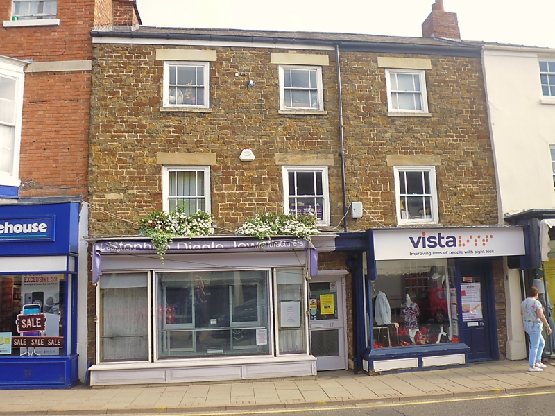
HIGH STREET
1.
1469
(North Side)
Nos 15 & 17
SK 8608 6/56
II GV
2.
Late C18 house. Coursed stone. Slate roof. Moulded wood eaves
cornice. Lions masks to guttering. 3-storeys. 3 windows, moulded
flush frames, flat stone arches, marginal glazing bars. Modern shop
front.
Nos 11 to 19 (odd) form a group.
Listing NGR: SK8610608756
External links are from the relevant listing authority and, where applicable, Wikidata. Wikidata IDs may be related buildings as well as this specific building. If you want to add or update a link, you will need to do so by editing the Wikidata entry.


Other nearby listed buildings
