Approximate Location Map
Large Map »
Latitude: 52.7675 / 52°46'2"N
Longitude: -2.3772 / 2°22'37"W
OS Eastings: 374645
OS Northings: 318939
OS Grid: SJ746189
Mapcode National: GBR 7Z.YR2Y
Mapcode Global: WH9CR.GP7R
Plus Code: 9C4VQJ8F+X4
Entry Name: 14 and 16, High Street
Listing Date: 29 June 1978
Grade: II
Source: Historic England
Source ID: 1178180
English Heritage Legacy ID: 255402
ID on this website: 101178180
Location: Newport, Telford and Wrekin, Shropshire, TF10
County: Telford and Wrekin
Civil Parish: Newport
Built-Up Area: Newport
Traditional County: Shropshire
Lieutenancy Area (Ceremonial County): Shropshire
Church of England Parish: Newport St Nicholas
Church of England Diocese: Lichfield
Tagged with: Building
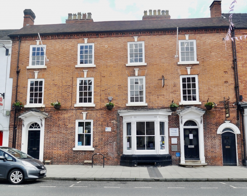
HIGH STREET
1.
5362
(East Side)
Nos 14 and 16
SJ 7418 NE 2/92
II GV
2.
Late C18. Red brick; 3 storeys; 4 sash windows with moulded keyblocks and
flat brick arches; corbelled eaves; tiles; 2 moulded wood doorcases with open
pediments on consoles, that to No 16 with radial fanlight; C19 splayed bay
window on right-hand side and a sash window to left.
Listing NGR: SJ7464518939
External links are from the relevant listing authority and, where applicable, Wikidata. Wikidata IDs may be related buildings as well as this specific building. If you want to add or update a link, you will need to do so by editing the Wikidata entry.


Other nearby listed buildings
