Approximate Location Map
Large Map »
Latitude: 52.3592 / 52°21'33"N
Longitude: -2.8763 / 2°52'34"W
OS Eastings: 340418
OS Northings: 273825
OS Grid: SO404738
Mapcode National: GBR BC.SGK0
Mapcode Global: VH76L.3Y8S
Plus Code: 9C4V945F+MF
Entry Name: Leintwardine Bridge
Listing Date: 19 February 1987
Grade: II
Source: Historic England
Source ID: 1180047
English Heritage Legacy ID: 149520
ID on this website: 101180047
Location: Leintwardine, County of Herefordshire, SY7
County: County of Herefordshire
Civil Parish: Leintwardine
Built-Up Area: Leintwardine
Traditional County: Herefordshire
Lieutenancy Area (Ceremonial County): Herefordshire
Church of England Parish: Wigmore Abbey
Church of England Diocese: Hereford
Tagged with: Road bridge
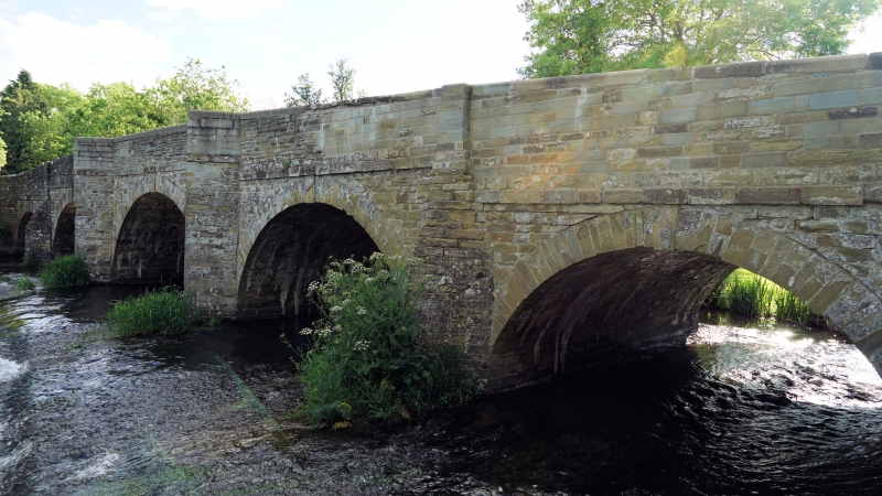
SO 4073-4173 LEINTWARDINE CP -
11/54 Leintwardine Bridge
GV II
Road bridge over River Teme. Probably C18 and C19, widened in 1930.
Roughly squared sandstone rubble with sandstone dressings. Aligned roughly
north/south. Five segmental arches stepped up to the middle, each with
dressed voussoirs and dropped keystone above which is a string course.
A sixth flood arch to the south has three order segmental head, the outer
order with a roll moulding on the west side. Four cutwaters to each side.
Plain parapets with dressed copings curve off the bridge to north-east,
north-west and south-east. Two refuges inside west parapet. Plaque on
east parapet indicates that the bridge was widened by 12 feet in 1930. Another
plaque is inscribed:
HCC
369
COUNTY BRIDGE
Listing NGR: SO4041873825
External links are from the relevant listing authority and, where applicable, Wikidata. Wikidata IDs may be related buildings as well as this specific building. If you want to add or update a link, you will need to do so by editing the Wikidata entry.


Other nearby listed buildings
