Approximate Location Map
Large Map »
Latitude: 51.5342 / 51°32'3"N
Longitude: -1.0708 / 1°4'14"W
OS Eastings: 464547
OS Northings: 182110
OS Grid: SU645821
Mapcode National: GBR B37.L49
Mapcode Global: VHCYX.DP8Q
Plus Code: 9C3WGWMH+MM
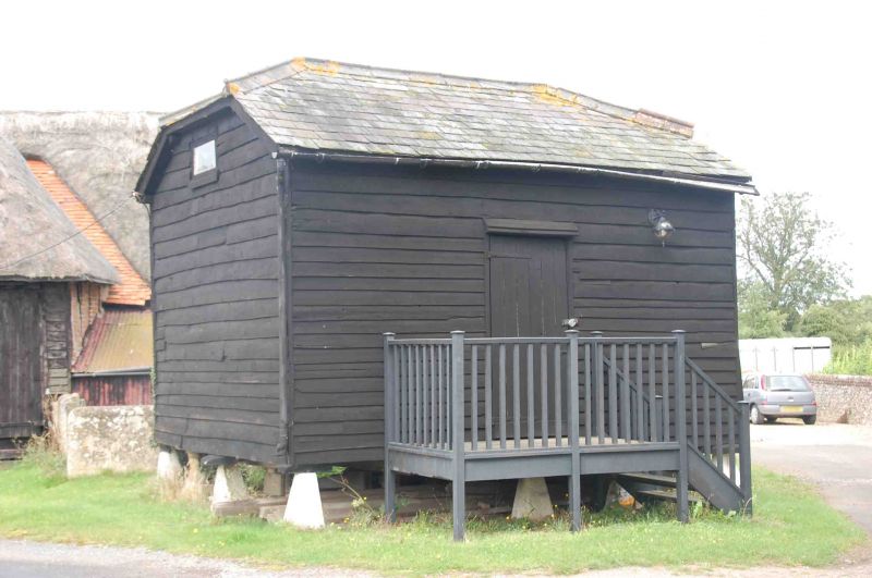
Entry Name: Granary Approximately 35 Metres South of Church Farmhouse
Listing Date: 16 August 1985
Grade: II
Source: Historic England
Source ID: 1180713
English Heritage Legacy ID: 247467
ID on this website: 101180713
Location: Woodcote, South Oxfordshire, RG8
County: Oxfordshire
District: South Oxfordshire
Civil Parish: Woodcote
Built-Up Area: Woodcote
Traditional County: Oxfordshire
Lieutenancy Area (Ceremonial County): Oxfordshire
Church of England Parish: Woodcote
Church of England Diocese: Oxford
Tagged with: Granary
SU68SW
5/250
WOODCOTE
READING ROAD
(North side)
Granary approx. 35m. S of Church Farmhouse
GV
II
Granary. Probably C19. Staddlestones; timber framing; weatherboarding; slate
half-hipped roof. Plank door to centre. Part of a complex of farm buildings.
Included for group value.
Listing NGR: SU6454782110
External links are from the relevant listing authority and, where applicable, Wikidata. Wikidata IDs may be related buildings as well as this specific building. If you want to add or update a link, you will need to do so by editing the Wikidata entry.


Other nearby listed buildings
