Approximate Location Map
Large Map »
Latitude: 51.3147 / 51°18'53"N
Longitude: -1.9429 / 1°56'34"W
OS Eastings: 404078
OS Northings: 157292
OS Grid: SU040572
Mapcode National: GBR 3WT.FMB
Mapcode Global: VHB4P.86RZ
Plus Code: 9C3W8374+VV
Entry Name: Unidentified Monument in Churchyard, Approximately 5 Metres South of South Transept, Church of St Michael
Listing Date: 25 March 1988
Grade: II
Source: Historic England
Source ID: 1182975
English Heritage Legacy ID: 312099
ID on this website: 101182975
Location: St Michael's Church, Urchfont, Wiltshire, SN10
County: Wiltshire
Civil Parish: Urchfont
Built-Up Area: Urchfont
Traditional County: Wiltshire
Lieutenancy Area (Ceremonial County): Wiltshire
Tagged with: Monument
URCHFONT CHURCH LANE
SU 0457
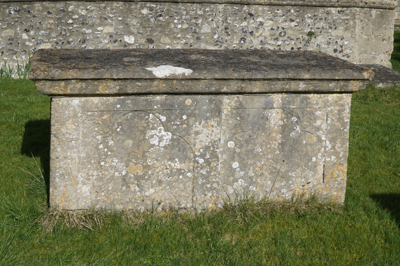
11/193 Unidentified monument in churchyard,
approximately 5m south of south
transept, Church of St Michael
II
Chest tomb. Early C19. Limestone. Cyma table. Side panels
lightly cut with trefoiled arches. Not read.
Listing NGR: SU0407857292
External links are from the relevant listing authority and, where applicable, Wikidata. Wikidata IDs may be related buildings as well as this specific building. If you want to add or update a link, you will need to do so by editing the Wikidata entry.


Other nearby listed buildings
