Approximate Location Map
Large Map »
Latitude: 51.5603 / 51°33'37"N
Longitude: 0.2302 / 0°13'48"E
OS Eastings: 554690
OS Northings: 186957
OS Grid: TQ546869
Mapcode National: GBR V8.8PW
Mapcode Global: VHHNF.Y11Q
Plus Code: 9F32H66J+43
Entry Name: Dury Falls
Listing Date: 7 January 1955
Grade: II
Source: Historic England
Source ID: 1184802
English Heritage Legacy ID: 201663
ID on this website: 101184802
Location: Hornchurch, Havering, London, RM11
County: London
District: Havering
Electoral Ward/Division: St Andrew's
Parish: Non Civil Parish
Built-Up Area: Havering
Traditional County: Essex
Lieutenancy Area (Ceremonial County): Greater London
Church of England Parish: Hornchurch St Andrew
Church of England Diocese: Chelmsford
Tagged with: Architectural structure
UPMINSTER ROAD
1.
5017
Hornchurch
TQ 58 NW 10/15 No 35 (Dury Falls)
7.1.55.
II
2.
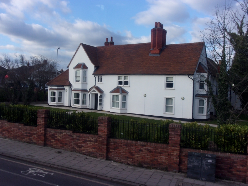
Early C17 timber-framed house with mid C17 and later additions. Two storeys,
rendered, colourwashed. Yarn front of 5 bays: the 3 eastern bays are the
earliest part of the building, the 2 western bays, one of which is roofed
at right angles to the main range, are a mid C17 addition. The cross-wing
has a 2 storey canted bay window, and there is a further single storey canted
bay to the east. All the windows have C19 sashes with cambered heads. Entrance
in fourth bay from west. Old tile roof. Fine brick stack with 6 diagonal
shafts. Two further shafts at north end of cross-wing. Timber-framed rear
wing with weatherboarded staircase turret on west side. Large C19 north wing.
Single storey C19 addition to the west of main front. Fish ponds or remains
of moat at the rear. (RCHM).
Listing NGR: TQ5469086957
External links are from the relevant listing authority and, where applicable, Wikidata. Wikidata IDs may be related buildings as well as this specific building. If you want to add or update a link, you will need to do so by editing the Wikidata entry.


Other nearby listed buildings
