Approximate Location Map
Large Map »
Latitude: 52.0732 / 52°4'23"N
Longitude: -1.3979 / 1°23'52"W
OS Eastings: 441364
OS Northings: 241822
OS Grid: SP413418
Mapcode National: GBR 7SK.TNK
Mapcode Global: VHBYR.Q5B0
Plus Code: 9C4W3JF2+7R
Entry Name: Sundial Farmhouse
Listing Date: 8 December 1955
Last Amended: 20 September 1988
Grade: II
Source: Historic England
Source ID: 1184849
English Heritage Legacy ID: 244773
ID on this website: 101184849
Location: Wroxton, Cherwell, Oxfordshire, OX15
County: Oxfordshire
District: Cherwell
Civil Parish: Wroxton
Built-Up Area: Wroxton
Traditional County: Oxfordshire
Lieutenancy Area (Ceremonial County): Oxfordshire
Church of England Parish: Wroxton with Balscote
Church of England Diocese: Oxford
Tagged with: Farmhouse
WROXTON MAIN STREET
SP4040-4140
(North side)
Sundial Farmhouse
10/216
(Formerly listed as Sundial
08/12/55
House (or Manor Farmhouse)
including stable with pigeon
loft over)
II
GV
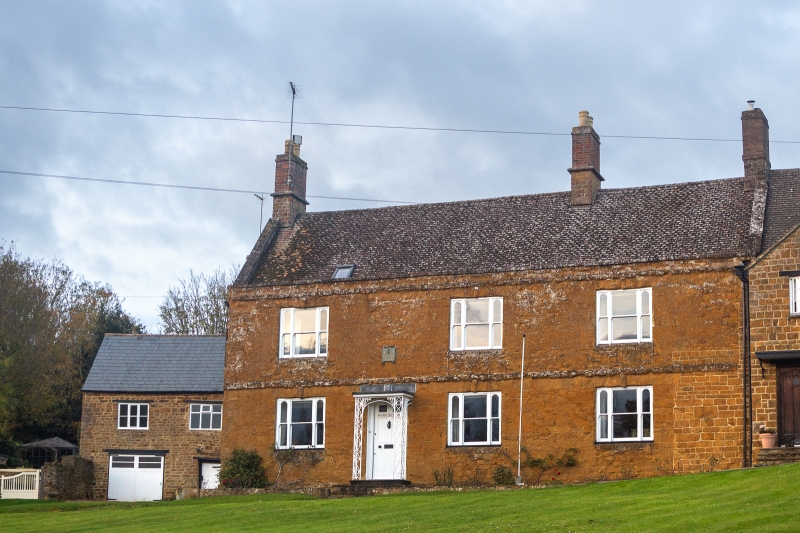
Farmhouse now house. C17 origins refronted in C18. Front elevation ironstone
ashlar. C20-tile roof with stone coped gables. 3 partly rebuilt stone ridge and
end stacks with brick shafts. 3-unit plan. 2 storeys. 3-window range. Entrance
to left has a fielded 6-panel door with 2 glazed panels and a C20 opening with
keyblock head. 2 similar windows to right. 3 similar first floor windows. Flat
band above first floor. Shallow stone parapet. Rear has gabled 2-storey
staircase turret. Interior: inglenook fireplace with stop-chamfered bressumer.
Present kitchen has stone fireplace with chamfered bressumer. Stop-chamfered and
chamfered beams. Closed-well staircase. 2-panelled C19 doors, C17 and C18
panelled doors with mouldings and blacksmith-made wrought-iron fasteners and
hinges. Stone flags. Cellar has a 2-light flat-splay stone mullioned window with
iron bars, chamfered beam and stone flag floor with drainage channel.
Through-purlin roof construction.
Listing NGR: SP4136441822
External links are from the relevant listing authority and, where applicable, Wikidata. Wikidata IDs may be related buildings as well as this specific building. If you want to add or update a link, you will need to do so by editing the Wikidata entry.


Other nearby listed buildings
