Approximate Location Map
Large Map »
Latitude: 51.2538 / 51°15'13"N
Longitude: 0.6905 / 0°41'25"E
OS Eastings: 587847
OS Northings: 153956
OS Grid: TQ878539
Mapcode National: GBR QSZ.7DT
Mapcode Global: VHJMH.XRD5
Plus Code: 9F327M3R+G6
Entry Name: Barn Circa 67 Yards North of Stede Hill
Listing Date: 26 April 1968
Grade: II
Source: Historic England
Source ID: 1185443
English Heritage Legacy ID: 173787
ID on this website: 101185443
Location: Maidstone, Kent, ME17
County: Kent
District: Maidstone
Civil Parish: Harrietsham
Traditional County: Kent
Lieutenancy Area (Ceremonial County): Kent
Tagged with: Barn
HARRIETSHAM STEDE HILL
TQ 85 SE (east side)
4/54 Barn circa 67 yards north
of Stede Hill
26.4.68.
II
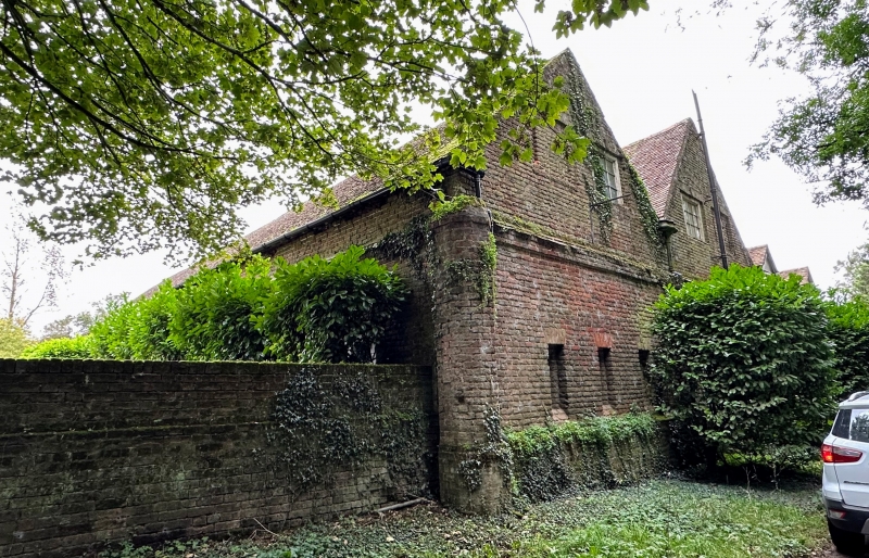
Barn. Late C17 with C18 and C19 alterations. Red brick with
occasional grey headers. Parts of north elevation in Flemish
bond, rest mixed. Plain tile roof. 2 parallel ranges at right-
angles to road. 1 1/2 storeys on brick plinth. String course, above
which wall slightly recessed, top of string course covered with
sloping plain tiles. North elevation: 6 ground-floor windows;
2-light glazing-bar casements with brick voussoirs, small raised
brick keystone and relieving arches. 2 C19 central buttresses
with roof brought down over and full-height double barn doors.
Street elevations: 6 blocked ground-floor slit windows with
double reveals, inner chamfered, and brick voussoirs. 2 blocked
first floor windows to each gable with voussoirs and keystones; 2 to
centre with C19 glazing-bar lights, 2 outer with 2 slits. Octagonal
brick pier to left corner. Brickwork continues to south as wall
of C19 cottage. Interior: No clear sign of floor. Broad brick
arcade between 2 ranges, originally 7 bays but central section
removed, probably in C19. Moulded plinths to piers, plain stone
imposts, semi-circular arches with deep voussoirs and raised brick
keystones. Windows in broad recesses with deep cills and segmental
heads. Roof of clasped and staggered but purlins, much altered,
to south range, C19 roof to north range.
Listing NGR: TQ8785054210
External links are from the relevant listing authority and, where applicable, Wikidata. Wikidata IDs may be related buildings as well as this specific building. If you want to add or update a link, you will need to do so by editing the Wikidata entry.


Other nearby listed buildings
