Approximate Location Map
Large Map »
Latitude: 51.1887 / 51°11'19"N
Longitude: 0.7027 / 0°42'9"E
OS Eastings: 588966
OS Northings: 146745
OS Grid: TQ889467
Mapcode National: GBR QTR.JGC
Mapcode Global: VHKKC.4DC3
Plus Code: 9F325PQ3+F3
Entry Name: Potter's Forstal Farmhouse
Listing Date: 10 October 1980
Grade: II
Source: Historic England
Source ID: 1186206
English Heritage Legacy ID: 180816
ID on this website: 101186206
Location: Potter's Forstal, Ashford, Kent, TN27
County: Kent
District: Ashford
Civil Parish: Egerton
Traditional County: Kent
Lieutenancy Area (Ceremonial County): Kent
Tagged with: Farmhouse
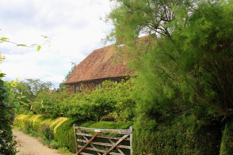
1.
5272 EGERTON CHAPEL ROAD
Potters Forstal
Potter's Forstal Farmhouse
TQ 84 NE 9/42
II
2.
C18 or earlier. Two storeys. Ground floor red brick, above tile-hung. Half-hipped
tiled roof with pentice behind. Three casement windows.
Listing NGR: TQ8896646745
External links are from the relevant listing authority and, where applicable, Wikidata. Wikidata IDs may be related buildings as well as this specific building. If you want to add or update a link, you will need to do so by editing the Wikidata entry.


Other nearby listed buildings
