Approximate Location Map
Large Map »
Latitude: 51.6551 / 51°39'18"N
Longitude: -0.0869 / 0°5'12"W
OS Eastings: 532434
OS Northings: 196876
OS Grid: TQ324968
Mapcode National: GBR H5.6RX
Mapcode Global: VHGQ7.FNXL
Plus Code: 9C3XMW47+26
Entry Name: Rivulet House
Listing Date: 31 January 1974
Grade: II
Source: Historic England
Source ID: 1189149
English Heritage Legacy ID: 200651
ID on this website: 101189149
Location: Enfield, London, EN2
County: London
District: Enfield
Electoral Ward/Division: Town
Parish: Non Civil Parish
Built-Up Area: Enfield
Traditional County: Middlesex
Lieutenancy Area (Ceremonial County): Greater London
Church of England Parish: St Andrew Enfield
Church of England Diocese: London
Tagged with: House
1.
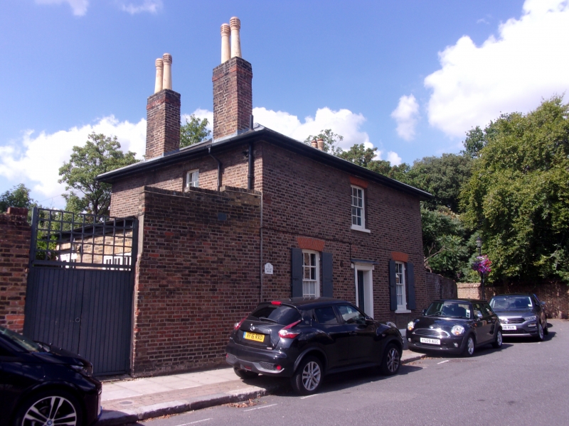
4411 GENTLEMAN'S ROW
(West Side)
No 32 Rivulet House)
TQ 3296 7/173
II
2.
Early-mid Cl9 2-storey small house with one window on 1st floor and 3 on ground
floor. Fairly low pitched hipped slate roof with eaves soffit. Red brick arches
of herringbone pattern to recessed sash windows with glazing bars. 4-panel door
under small flat hood.
Listing NGR: TQ3243496876
External links are from the relevant listing authority and, where applicable, Wikidata. Wikidata IDs may be related buildings as well as this specific building. If you want to add or update a link, you will need to do so by editing the Wikidata entry.


Other nearby listed buildings
