Approximate Location Map
Large Map »
Latitude: 52.9096 / 52°54'34"N
Longitude: -2.0773 / 2°4'38"W
OS Eastings: 394898
OS Northings: 334685
OS Grid: SJ948346
Mapcode National: GBR 26Y.PLN
Mapcode Global: WHBDG.2428
Plus Code: 9C4VWW5F+R3
Entry Name: Lower Farmhouse
Listing Date: 25 April 1980
Grade: II
Source: Historic England
Source ID: 1189479
English Heritage Legacy ID: 272251
ID on this website: 101189479
Location: Hilderstone, Stafford, Staffordshire, ST15
County: Staffordshire
District: Stafford
Civil Parish: Hilderstone
Traditional County: Staffordshire
Lieutenancy Area (Ceremonial County): Staffordshire
Church of England Parish: Hilderstone Christ Church
Church of England Diocese: Lichfield
Tagged with: Farmhouse
1.
5373
SJ 93 SW
11/8
HILDERSTONE
HILDERSTONE ROAD
Hilderstone
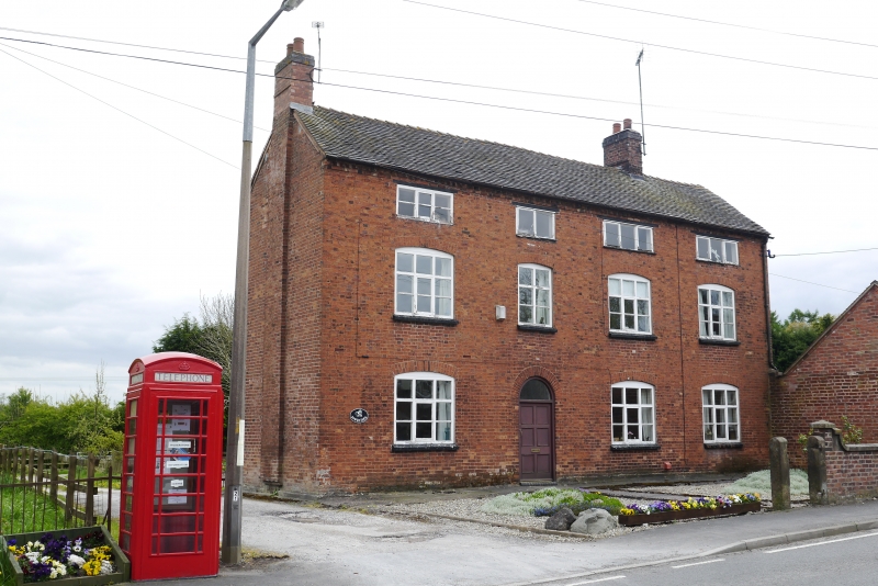
Lower Farmhouse
II
2.
Early C19. Red brick; 3 storeys; 4 casement windows with cambered heads; plain
wood doorway with plain semi-circular fanlight; dog-tooth eaves; tiles.
Listing NGR: SJ9489834685
External links are from the relevant listing authority and, where applicable, Wikidata. Wikidata IDs may be related buildings as well as this specific building. If you want to add or update a link, you will need to do so by editing the Wikidata entry.


Other nearby listed buildings
