Approximate Location Map
Large Map »
Latitude: 51.6901 / 51°41'24"N
Longitude: -1.2029 / 1°12'10"W
OS Eastings: 455194
OS Northings: 199343
OS Grid: SU551993
Mapcode National: GBR 8ZS.W52
Mapcode Global: VHCY2.3SF6
Plus Code: 9C3WMQRW+3R
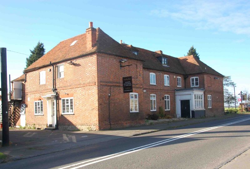
Entry Name: The Harcourt Arms Inn
Listing Date: 18 July 1963
Last Amended: 19 August 1986
Grade: II
Source: Historic England
Source ID: 1193363
English Heritage Legacy ID: 248302
ID on this website: 101193363
Location: Nuneham Courtenay, South Oxfordshire, OX44
County: Oxfordshire
District: South Oxfordshire
Town: South Oxfordshire
Civil Parish: Nuneham Courtenay
Traditional County: Oxfordshire
Lieutenancy Area (Ceremonial County): Oxfordshire
Church of England Parish: Marsh Baldon with Toot Baldon and Nuneham Courtenay
Church of England Diocese: Oxford
Tagged with: Inn
NUNEHAM COURTENAY A423
SU5599 (West side)
9/65 The Harcourt Arms Inn
18/07/63 (Formerly listed as Harcourt
Arms including stable block)
GV II
Inn. Mid C18, altered and extended mid C19. Brick in Flemish bond with some
flared headers; old plain-tile roof with brick stacks. H-plan. 2 storeys plus
attic. Front in chequer brick with stepped plinth, storey band and dentil eaves
course, has projecting wings and a 4-window central range with 2 leaded cross
windows at ground floor and 2-light casements at first floor. Wings have similar
windows set towards their inner corners, blind at first floor, and their
inward-facing return walls also have a first floor-casement. All have segmental
arches. The left bay of the main range has an entrance with architrave, flat
canopy on shaped brackets, and rectangular overlight, and the right inner angle
has a large glazed wooden porch with Doric columns. Roofs are hipped with 2
hipped roof dormers in the central range. 3-window right return wall has been
extended by one bay and has some mid C19 rubbed-brick flat arches. It retains a
cross window to extreme left. Left return wall also has some rubbed-brick flat
arches. The building forms the northern termination to the village street,
balancing the former smithy (Brewers of Nuneham Ltd., q.v.). Part of the estate
village built c.1760 for the 1st Earl Harcourt.
(M. Batey "Nuneham Courtenay, an Oxfordshire C18 deserted village", Oxoniensia
Vol. ST, 1968, p.108).
Listing NGR: SU5519499343
External links are from the relevant listing authority and, where applicable, Wikidata. Wikidata IDs may be related buildings as well as this specific building. If you want to add or update a link, you will need to do so by editing the Wikidata entry.


Other nearby listed buildings
