Approximate Location Map
Large Map »
Latitude: 52.7559 / 52°45'21"N
Longitude: 0.3922 / 0°23'31"E
OS Eastings: 561531
OS Northings: 320276
OS Grid: TF615202
Mapcode National: GBR N3Q.9YP
Mapcode Global: WHJP1.0Z0L
Plus Code: 9F42Q94R+9V
Entry Name: Crown and Mitre public house
Listing Date: 1 December 1951
Last Amended: 3 August 2018
Grade: II
Source: Historic England
Source ID: 1195308
English Heritage Legacy ID: 384100
Also known as: Crown and Mitre
The Crown and Mitre, King's Lynn
ID on this website: 101195308
Location: King's Lynn, King's Lynn and West Norfolk, Norfolk, PE30
County: Norfolk
District: King's Lynn and West Norfolk
Electoral Ward/Division: St Margarets with St Nicholas
Parish: Non Civil Parish
Built-Up Area: King's Lynn
Traditional County: Norfolk
Lieutenancy Area (Ceremonial County): Norfolk
Tagged with: Pub
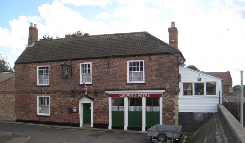
A public house, though to have late C16 origins, altered and extended in the C20 and C21.
A mid-late C19 public house, believed to have C16 origins, now with C20 and C21 alterations and extensions.
MATERIALS: Red brick laid to Flemish bond, with a C20 pantile roof covering.
PLAN: The building is roughly L-shaped on plan with a crosswing to the west end.
EXTERIOR: The building is of two storeys, the north-facing front elevation to Ferry Street comprising three original bays rising from a shallow painted plinth, now with an added lean-to at the east end replacing earlier fabric. The roof is hipped at the west end, and incorporates brick chimneys at both ends. There is a dentilled storey band which extends along the full length of the front elevation and returns along the west gable. Below the band at the north-west corner is a section of small limestone quoins. The brickwork above the storey band appears to be later than that below. The main entrance doorway has a painted doorcase with an open pediment and a six-panel door. To the right of the doorway is a C19 display window, set below a moulded fascia, which lights the interior of the public house's main bar area. The three-sections of this opening are defined by timber pilasters with capitals and bases, and within the upper part of each section is a two-light window, each light with a shallow-arched head. The lights are separated by rounded mullions. To the left of the doorway is an eight over eight-pane sash window set beneath a plain soldier arch. There are three upper floor windows all with glazing bar sash frames, the central opening narrower with a six over six-pane frame. The openings all have rubbed brick heads. Extending along the west gable and the west wing is a long C21 glazed extension which now encloses a canted upper floor oriel window. The glazed extension is not of special interest. At the east end is a C21 lean-to extension built of salvaged bricks, also not of special interest.
INTERIOR: The interior of the public house has been largely remodelled at ground floor level to create a single open-plan bar and is mostly of C20 or C21 date, replacement timber beams now supporting the upper floor area. The bar is entered via a small lobby with the bar counter and back bar located against the west side wall. Extending to the east at the rear of the bar area is a smaller dining room with a brick hearth and chimney breast to the east end wall. The hearth has a curved back wall and a deep bressemer. A staircase and landing at the rear of the bar area gives access to the first floor and the roof space, and has turned balusters to the incline and landing area and some rectangular panelling to the stair side wall. The roof structure is mostly of C20 and C21 date.
King’s Lynn, first called Bishop’s Lynn, was founded in 1095 by Bishop Herbert de Losinga, who in the previous year had transferred the see from Thetford to Norwich. There was already an existing settlement which appears to have been based around a salt-water lagoon, or series of inlets, with its centre round the present All Saints Church. Losinga’s town developed to the north of this, between All Saints Church and Saturday Market Place where St Margaret’s Church and Priory were established from Norwich around 1100. Rapid expansion from the C12 onwards required an extension of the town, and Bishop William Turbe laid out a new settlement north of the Purfleet from around 1145, with its market at Tuesday Market Place and the Chapel of St Nicholas as a chapel of ease to St Margaret’s. Both settlements were united under a royal charter in 1204, the united town being named Bishop’s Lynn. Until the early C13, the Great Ouse emptied via the Wellstream at Wisbech, however following floods in the C13, the river was redirected to join the Wash at Bishop’s Lynn. The town became one of England’s busiest ports, serving the Ouse and its tributaries, exporting wool and cloth, and importing wine, timber and luxury goods, being adopted as a member of the original medieval Hanseatic League. This extremely influential trading association linked a group of towns around the Baltic and the North Seas, and played an important role in the prosperity and development of Bishop’s Lynn as a national port, which by the C14, was ranked as the third port of England (after London and Southampton).
Losinga’s town round the Saturday Market was protected from the river immediately to its west by the ‘great bank’, an earthwork which ran along the present line of Nelson Street, St Margaret’s Place and Queen Street. By about 1500 the river had moved approximately 50m west and was consolidated another 45m by the new South Quay in 1855. The period of development of the area between the Millfleet and Purfleet can therefore be identified, as well as building types and plans. The generous-sized plots are reflected in the surviving buildings dating from the C14 to the C17, which surround open courtyards. To the north, on Bishop Turbe’s ‘newe lande’, much the same pattern emerges: originally the west side of Tuesday Market Place was washed by the river, with King Street forming the line of the bank. The west side of King Street was built upon in the C13, with narrow plots, elongating in stages until river movement ceased in the C17. As land became available, warehouses were built straight onto the river front. When Henry VIII dissolved the monasteries in 1536-1537, the town and manor became royal property, and Bishop’s Lynn was renamed King’s Lynn or Lynn Regis.
Lynn’s prosperity as a national port was based entirely on trade, and the merchant class dominated the social and economic life of the town until the C19. When the Fens began to be drained in the mid-C17 and land turned to agricultural use, King’s Lynn grew prosperous from the export of corn: cereal export dominated from the C16, and especially in the C18. Coal and wine continued to be imported for distribution inland, and until the railway age, Lynn was the chief East Anglian port for both. Prosperity continued until continental trade was disturbed by the Napoleonic Wars (1803-1815), followed by a brief revival. The economy and population dwindled following the relatively late arrival of railway services to King’s Lynn in 1847, compounded by the irrevocable decline of coastal trading.
The Crown and Mitre public house is believed to have late C16 origins, although the present building is largely of C19 and C20 date. The late C19 phase of its history is represented externally by the entrance doorway and the main display window, set within what is thought to be C18 or earlier brickwork. In the late C20 and C21 the interior of the bar area was repaired and largely remodelled and refitted, and extensions were added to both ends of the building.
The Crown and Mitre public house on Ferry Street, King's Lynn, is listed at Grade II for the following principal reasons:
Historic interest :
* as a building believed to have C16 origins, becoming a public house located on the eastern bank of the Great Ouse, on the edge of the historic Common Staithe Quay.
Architectural interest:
* as a waterside public house incorporating what is thought to be surviving late C16 fabric, and with late C18 and C19 external detailing.
External links are from the relevant listing authority and, where applicable, Wikidata. Wikidata IDs may be related buildings as well as this specific building. If you want to add or update a link, you will need to do so by editing the Wikidata entry.


Other nearby listed buildings
