Approximate Location Map
Large Map »
Latitude: 52.7572 / 52°45'25"N
Longitude: 0.3965 / 0°23'47"E
OS Eastings: 561818
OS Northings: 320421
OS Grid: TF618204
Mapcode National: GBR N3Q.51V
Mapcode Global: WHJP1.2Y2N
Plus Code: 9F42Q94W+VH
Entry Name: Listergate, 80 Chapel Street and associated boundary wall
Listing Date: 7 June 1972
Last Amended: 31 August 2018
Grade: II
Source: Historic England
Source ID: 1195344
English Heritage Legacy ID: 384089
ID on this website: 101195344
Location: North End, King's Lynn and West Norfolk, Norfolk, PE30
County: Norfolk
District: King's Lynn and West Norfolk
Electoral Ward/Division: St Margarets with St Nicholas
Parish: Non Civil Parish
Built-Up Area: King's Lynn
Traditional County: Norfolk
Lieutenancy Area (Ceremonial County): Norfolk
Tagged with: Building
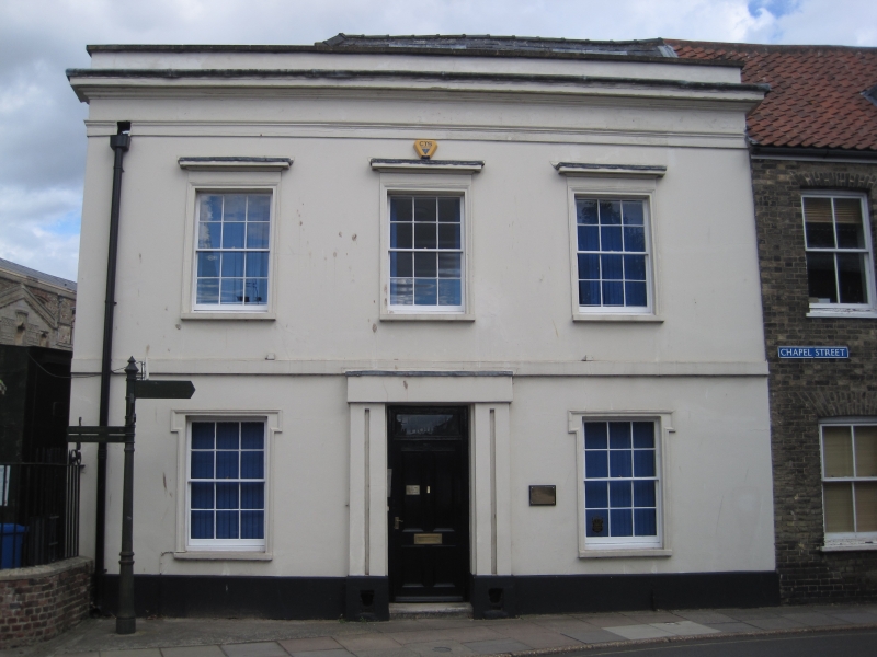
Red brick house, built in the late C18, extended in the late C18 or early C19, and again in mid-C20, now offices. Associated boundary wall to rear.
Red brick house, built in the late C18, extended in the late C18 or early C19, and again in mid-C20, now offices. Associated boundary wall to rear.
MATERIALS: Red brick, with a rendered front elevation to Chapel Street. Red brick to late-C18 or early-C19 extension, and mid-C20 extension.
PLAN: L-plan building, having a rectangular-plan block facing west to Chapel Street, and two rectangular-plan extensions to the rear (east).
EXTERIOR: Two-storey house with an attic storey, built in the late C18, and extended to the rear in the late C18 or early C19, and again in the mid-C20. The slate roof is hipped to the front rectangular section, and gabled to the rear projection, with a red brick chimney stack to the ridge. The attic dormers and mid-C20 extension each have flat roofs. The front (west) elevation to Chapel Street is rendered, and comprises a symmetrical three-bay two-storey elevation, with dormers to the attic. The front elevation has a projecting cornice to the parapet, and a plain platband over the ground floor. The first floor windows have plain cornices over, and lugged architraves to the ground floor windows. The windows are six-over-six pane timber sash windows, with timber casements to the attic. The central door surround is plain, with an engaged channelled pilaster to either side of the door, with an original cast-iron boot scrape to each base. The door was replaced in the late C20 or early C21, and has a plain rectangular overlight. The side elevation, facing north to the Chapel of St Nicholas, is also two storeys in height with an attic. It is composed of red brick in two clear stages: the late-C18 building incorporates some ashlar rubble at ground floor level; and the late-C18 or early C19 extension skews slightly southward, with a plain platband over the ground floor. There are two bays of windows, the eastern first floor window having nine panes over six. The rear (east) elevation is gabled and two-and-half storeys in height, with a mid-C20 flat-roofed two-storey extension to the east.
INTERIOR: The interior retains the majority of its original plan form, with the exception of the removal of the ground-floor wall between the entrance hall and reception, and the insertion of a number of partition walls sub-dividing ground and first floor rooms. On the ground floor, a central corridor provides access from the front entrance, through a round arch with engaged pilasters, to the stair hall at the rear. The north-west office (facing west to Chapel Street) was sub-divided in the late C20 or early C21, and retains part of its decorative cornice and window shutters in the eastern section. The stair hall (located in the late-C18 or early-C19 extension) retains an early plaster rosette (light fitting removed), and the stair comprises timber treads and slender turned balusters under a moulded handrail. Under the stair, a brick-lined cellar survives, and to the rear a small kitchen occupies the ground floor of the mid-C20 extension. At the turn of the stairs, three steps provide access to a first-floor office in the mid-C20 extension, by way of what was formerly a stair window. On the first floor, a central corridor provides access to offices to the north and south (those to the front being subdivided). As on the ground floor, the central corridor has a round-headed arch with engaged pilasters. To the south of the corridor an arch provides access to what is now a toilet corridor, with an elliptical-headed niche on the east wall. From the first floor, the main stair rises to the attic, where the central corridor has a wide elliptical-headed arch.
SUBSIDIARY FEATURES: A red brick wall extends eastwards from the north elevation, enclosing a small rear yard, having a round-arched opening containing a square-headed timber door to the churchyard of the Chapel of St Nicholas.
King’s Lynn, first called Bishop’s Lynn, was founded in 1095 by Bishop Herbert de Losinga, who in the previous year had transferred the see from Thetford to Norwich. There was already an existing settlement which appears to have been based around a salt-water lagoon, or series of inlets, with its centre round the present All Saints Church. Losinga’s town developed to the north of this, between All Saints Church and Saturday Market Place where St Margaret’s Church and Priory were established from Norwich around 1100. Rapid expansion from the C12 onwards required an extension of the town, and Bishop William Turbe laid out a new settlement north of the Purfleet from around 1145, with its market at Tuesday Market Place and the Chapel of St Nicholas as a chapel of ease to St Margaret’s. Both settlements were united under a royal charter in 1204, the united town being named Bishop’s Lynn. Until the early C13, the Great Ouse emptied via the Wellstream at Wisbech, however following floods in the C13, the river was redirected to join the Wash at Bishop’s Lynn. The town became one of England’s busiest ports, serving the Ouse and its tributaries, exporting wool and cloth, and importing wine, timber and luxury goods, being adopted as a member of the original medieval Hanseatic League. This extremely influential trading association linked a group of towns around the Baltic and the North Seas, and played an important role in the prosperity and development of Bishop’s Lynn as a national port, which by the C14, was ranked as the third port of England (after London and Southampton).
Losinga’s town round the Saturday Market was protected from the river immediately to its west by the ‘great bank’, an earthwork which ran along the present line of Nelson Street, St Margaret’s Place and Queen Street. By about 1500 the river had moved approximately 50m west and was consolidated another 45m by the new South Quay in 1855. The period of development of the area between the Millfleet and Purfleet can therefore be identified, as well as building types and plans. The generous-sized plots are reflected in the surviving buildings dating from the C14 to the C17, which surround open courtyards. To the north, on Bishop Turbe’s ‘newe lande’, much the same pattern emerges: originally the west side of Tuesday Market Place was washed by the river, with King Street forming the line of the bank. The west side of King Street was built upon in the C13, with narrow plots, elongating in stages until river movement ceased in the C17. As land became available, warehouses were built straight onto the river front. When Henry VIII dissolved the monasteries in 1536-1537, the town and manor became royal property, and Bishop’s Lynn was renamed King’s Lynn or Lynn Regis.
Lynn’s prosperity as a national port was based entirely on trade, and the merchant class dominated the social and economic life of the town until the C19. When the Fens began to be drained in the mid-C17 and land turned to agricultural use, King’s Lynn grew prosperous from the export of corn: cereal export dominated from the C16, and especially in the C18. Coal and wine continued to be imported for distribution inland, and until the railway age, Lynn was the chief East Anglian port for both. Prosperity continued until continental trade was disturbed by the Napoleonic Wars (1803-1815), followed by a brief revival. The economy and population dwindled following the relatively late arrival of railway services to King’s Lynn in 1847, compounded by the irrevocable decline of coastal trading.
Listergate, or 80 Chapel Street was built at the junction of Chapel Street, St Nicholas Street and St Ann’s Street in the late C18, most likely replacing an earlier building on the same site. Chapel Street was previously known as Listergate, the name likely referring to the listerers or dyers of the area. The nearby area of Damgate (now Norfolk Street East) and Webstar Row (now Broad Street) were also associated with cloth-making activities, with a fulling mill built near the north-eastern end of Damgate in the 1390s. The Newlond Survey, a detailed written survey of Bishop’s Lynn taken around 1270, describes 'the chapel with the cemetery of St Nicholas [which] includes all the ground with its buildings between the road next to the chapel on the north and the road leading to 'ertishrigge' on the south' (now Austin Street). It is therefore probable that the earlier building on this site supported the activities of the neighbouring chapel, and the site is shown as being occupied on the 1725 plan of King’s Lynn by William Rastrick.
It appears that the front section of the house (facing Chapel Street) was constructed in the late C18, and was extended to the rear (east) in the late C18 or early C19, and again in the mid-C20. 80 Chapel Street was in residential use until approximately 1970, after which it was utilised as commercial offices. It is likely that the front dormers were added in the late C18 or early C19 when the rear extension was added, and are certainly visible in early C20 aerial photography of the area. The dormers to the north slope were added around 1993.
80 Chapel Street, built in the late C18, extended in the late C18 or early C19, and again in mid-C20, now offices, is listed at Grade II for the following principal reasons:
Architectural interest:
* as a prominently sited and distinctively detailed late-C18 town house;
* for the survival of a high proportion of the original plan form and historic fabric, including an attractive late-C18 or early-C19 stair hall.
Group value:
* for the strong group value it holds with many nearby listed buildings on St Nicholas Street and Chapel Street, notably the neighbouring Chapel of St Nicholas (listed at Grade I), the Tudor Rose Hotel (listed at Grade II*), and 26 St Nicholas Street and 78 Chapel Street (both listed at Grade II).
External links are from the relevant listing authority and, where applicable, Wikidata. Wikidata IDs may be related buildings as well as this specific building. If you want to add or update a link, you will need to do so by editing the Wikidata entry.


Other nearby listed buildings
