Approximate Location Map
Large Map »
Latitude: 52.754 / 52°45'14"N
Longitude: 0.3927 / 0°23'33"E
OS Eastings: 561575
OS Northings: 320061
OS Grid: TF615200
Mapcode National: GBR N3Q.B42
Mapcode Global: WHJP7.018J
Plus Code: 9F42Q93V+J3
Entry Name: 18-19 Purfleet Quay, Cellars, and attached wall to the east (formerly listed as Offices of Robert Freakley and Associates)
Listing Date: 1 December 1951
Last Amended: 12 June 2018
Grade: II
Source: Historic England
Source ID: 1195415
English Heritage Legacy ID: 384241
ID on this website: 101195415
Location: King's Lynn, King's Lynn and West Norfolk, Norfolk, PE30
County: Norfolk
District: King's Lynn and West Norfolk
Electoral Ward/Division: St Margarets with St Nicholas
Parish: Non Civil Parish
Built-Up Area: King's Lynn
Traditional County: Norfolk
Lieutenancy Area (Ceremonial County): Norfolk
Tagged with: Office building
18-19 Purfleet Quay (formerly listed as Offices of Robert Freakley and Associates), quayside warehousing built in the early C17 with later ranges and perhaps with surviving earlier fragments.
18-19 Purfleet Quay, cellars and attached wall to the east (formerly Warehouse of P Cortlandt; formerly Offices of Robert Freakley Associates), King's Lynn.
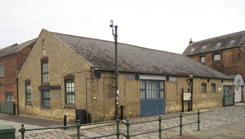
Warehouse, now offices, constructed in the early C17, probably with earlier origins, and with later alterations and additions, especially of the mid-C19, but also a late C20 modern entrance way off Purfleet Quay and late C20 refurbishment. The site comprises three main ranges, north, east and west.
MATERIALS: The ranges are of red and yellow brick with blue engineering brick lintels, and stone quoins and dressings in part. The roofs are slate covered.
PLAN: Formed of three main blocks on plan, a square building to the east, here called the ‘East Range’, adjoined by a rectangular building to the west, built on an east/west alignment, here called the ‘West Range’. These together form the front onto Purfleet Quay. The square, East Range is adjoined to the north by a rectangular block running east/west, here called the 'North Range'. In addition there is an adjoining range, on a north/south alignment, to the north-west, which is not included (save one bay) in the listing.
EXTERIOR
East Range
A gabled East Range of four storeys and three bays, constructed of red-brick laid to English bond, exhibiting evidence of alteration through the colour and variations in the brick, and remnants of brick plinths. The roof is slate-covered with skylights and has a small stack and chimney pot on the ridge at the north end. At ground-floor level the doorway (with a four-panel timber door under a rectangular light) occupies the central bay, with a nine-pane window on each side. To the left, stone quoins rise from ground to lintel level. Window openings of the two, lower storeys are under blue engineering brick, segmental-arch lintels, and have flush, stone cills. The first floor is lit by two, wide window openings with a circular tie plate centrally placed above the segmental-arched lintel of each, and one more to the right side. Small square windows light the two upper storeys, the three at second-floor level are set in splayed, stone frames, with some renewal; the two at third-floor level are set in weathered, ovolo-moulded, stone frames. The gable has brick coping and two ‘S’-shaped, tie plates. To the left there is a moulded stone kneeler, but not to the right where there is some disruption in the brickwork. The upper floors of the elevation are dominated by a large, rectangular (with a central arch) sign plate formed of cement render (fragments of paint remain, formerly reading P.CORTLANDT DRY STORAGE) in a bolection moulded stone frame.
Adjoining to the right side there is a red-brick (with variations) lean-to with a cat slide roof, adjoining up to second-floor level. This has a timber, loading-bay door under a simple flat brick lintel, above a square, timber hatch, and with a round headed brick plinth below. The division of the lean-to from the square block of the East Range is marked at its upper level by a straight joint, and the brickwork of the corner of the square block is closed. The square block and the lean-to are bonded beneath the hatch, however. To the right, a doorway with a modern, timber, double door gives access to the cellars beneath. Adjoining further to the right, a yard wall connects to the rear of No 1 King Street, and a vehicular access, under a concrete lintel, leads to a yard on the east side. A straight joint shows further evidence of change and a blocked window to the right of the vehicular access implies it was once the quayside wall of a building.
From the east, various straight joints and blockings can be seen in the East Range, east elevation. Notably at ground-floor level, there is a round-headed opening formed of a brick head and stone dressings, filled with modern brick. Stone quoins at the north-east corner of the square block mark the junction between it and the rectangular range to the north-west. At the upper-floor level, to the left, a large rendered, rectangular sign shows the faded inscription: HEADQUARTERS / ARMY SERVICES / NORFOLK & SUFFOLK BRIGADE, overlain in faded white paint with TO LET. Below, the mono-pitch brick lean-to has blocked openings.
The west elevation is not easily visible, but has straight joints denoting some changes similar to the east elevation, and window openings under blue-brick segmental arches. The north elevation appears to be rendered.
West Range
The East Range is adjoined to a yellow-brick (laid to English bond), single-storey range to the west by a modern entrance way with a round-headed, metal porch and gates. The West Range stands under a pitched, slate-covered roof, gabled to the west and hipped to the east. The opening of a vehicle access at the west end is now glazed and panelled, and there are two small windows to its east, and a further large vehicular opening towards the east end, again now glazed. Under the eaves there is a row of six circular tie plates. The west elevation of this range is of three bays, the outer bays containing small-pane, timber, transom opening windows on brick cills (all modern), and under C19, red-brick segmental arches. A similar window opening is in the central bay at a raised level above a small modern window under a long timber lintel. In the gable, two stones are set into the brickwork: one, a date stone, weathered but apparently inscribed: T / I I / 1676. The other, probably C19, is inscribed F.P.P.
The north elevation is of red brick and is a survival from a C16 or C17 building. The brick bonding is inconsistent, especially around two C16 or C17, four-centre brick arches to the north end. The most northern one has lost its impost which has recently been rebuilt in yellow brick and which forms part of the right-hand reveal of a large glazed (modern) opening to the left under a modern concrete lintel. To the right of the arches, two window openings, and a doorway at the west end, with engineering brick segmental arches, were introduced in the mid-C19.
Adjoining the West Range at the north-west corner is a C20, red-brick range with a vehicular entrance that gives access to the enclosed yard. A single bay south of the vehicular access forms part of the premises of 18-19 Purfleet Quay at the lower level and is included in the listing. It contains earlier brickwork at ground-floor level, apparently contemporary with the north wall of the West Range. The remainder of this range is not included in the listing.
North Range
Adjoining the West Range at its north-east corner and running along the rear of the East Range, is the North Range, a two-storey, brick building under a slate-covered hipped roof. Its west elevation is of red brick (English Bond). Access is gained by a doorway right of centre under a lead-covered lintel. Above this, on the inside there is a blocked opening or recess with a timber lintel. A central glazed opening (stepped at cill level), within modern brickwork internally, lights the upper-floor level. The north elevation is of red brick and blind, and shows evidence of the relaying of brick work under the eaves, with concrete beam ends apparent. The north elevation has three bays of full height glazing between brick piers at the west end, with a doorway at the west corner, and this appears to be late C20 in date. The remaining four bays have brick pilasters at each end and a small-paned window west of three small windows under red-brick, segmental arches, at ground-floor level. There is a doorway at the east end. The east end adjoins the neighbouring building at ground-floor level and is otherwise clad in slate under a hipped east end.
INTERIOR
The interior of the East Range is plain with modern plasterwork, doors and skirtings. The stairs too appear to be modern. At ground-floor level there are two blocked, round-headed brick arches in the east wall and a third in the north wall. The timber-lined roof is supported by late C19 king-post trusses with angled braces, trenched purlins and an iron strap at the base of the king post.
The interior of the West Range is converted to office use and appears to contain no fixtures and fittings of historic interest. However, a single bay of the C20 brick range which adjoins the West Range at the north-west corner, contains earlier brickwork which is perhaps contemporary with the north wall of the West Range. The ground-floor room contains a fragment of a four-centre brick arch, exposed in the west wall. The remainder of this range was not inspected and (as already noted) is not included in the listing.
The interior of the North Range is altered and converted for offices and storage. Historic brickwork of the west wall is exposed internally revealing a blocked opening with a timber lintel, and at this end the building is open to its full height with a modern stair up to the first-floor At the east end, modern stairs and partitioning partially conceal substantial, historic timber ceiling joists, perhaps of C16 or C17 date, spanning three bays at the east end of this range. At first-floor level there is a modern suspended ceiling and axial, modern, glazed partitioning.
There is external access to extensive cellars, probably of at least C16 or C17 origin, that appear to extend beyond the footprint of the present buildings above. A hoist with a timber drum survives inside the entrance way but it is unclear if this is fixed in place. There are brick steps down to three parallel, elliptically-vaulted ranges running east-west, linked at intervals. Goad plans of 1933 indicate a further range to the north. The cellars are of brick; cement rendered in part. There is some historic patching and some modern blocking in brick and cement breeze block. Arched openings, some with pintles but no doors, vary in form from round to four-centred arches, and support is offered in one section by plain, chamfered, brick ribbing.
Detached buildings to the north of the yard and the attached warehouse to the north-west are excluded from the listing. However, where beneath these buildings, cellars run that form part of the cellars for 18-19 Purfleet Quay or are attached below ground to the cellars of 18-19 Purfleet Quay, these cellars are included in the listing.
King’s Lynn, first called Bishop’s Lynn, was founded in 1095 by Bishop Herbert de Losinga, who in the previous year had transferred the see from Thetford to Norwich. There was already an existing settlement which appears to have been based around a salt-water lagoon, or series of inlets, with its centre round the present All Saints Church. Losinga’s town developed to the north of this, between All Saints Church and Saturday Market Place where St Margaret’s Church and Priory were established from Norwich around 1100. Rapid expansion from the C12 onwards required an extension of the town, and Bishop William Turbe laid out a new settlement north of the Purfleet from around 1145, with its market at Tuesday Market Place and the Chapel of St Nicholas as a chapel of ease to St Margaret’s. Both settlements were united under a royal charter in 1204, the united town being named Bishop’s Lynn. Until the early C13, the Great Ouse emptied via the Wellstream at Wisbech, however following floods in the C13, the river was redirected to join the Wash at Bishop’s Lynn. The town became one of England’s busiest ports, serving the Ouse and its tributaries, exporting wool and cloth, and importing wine, timber and luxury goods, being adopted as a member of the original medieval Hanseatic League. This extremely influential trading association linked a group of towns around the Baltic and the North Seas, and played an important role in the prosperity and development of Bishop’s Lynn as a national port, which by the C14, was ranked as the third port of England (after London and Southampton).
Losinga’s town round the Saturday Market was protected from the river immediately to its west by the ‘great bank’, an earthwork which ran along the present line of Nelson Street, St Margaret’s Place and Queen Street. By about 1500 the river had moved approximately 50m west and was consolidated another 45m by the new South Quay in 1855. The period of development of the area between the Millfleet and Purfleet can therefore be identified, as well as building types and plans. The generous-sized plots are reflected in the surviving buildings dating from the C14 to the C17, which surround open courtyards. To the north, on Bishop Turbe’s ‘newe lande’, much the same pattern emerges: originally the west side of Tuesday Market Place was washed by the river, with King Street forming the line of the bank. The west side of King Street was built upon in the C13, with narrow plots, elongating in stages until river movement ceased in the C17. As land became available, warehouses were built straight onto the river front. When Henry VIII dissolved the monasteries in 1536-1537, the town and manor became royal property, and Bishop’s Lynn was renamed King’s Lynn or Lynn Regis.
Lynn’s prosperity as a national port was based entirely on trade, and the merchant class dominated the social and economic life of the town until the C19. When the Fens began to be drained in the mid-C17 and land turned to agricultural use, King’s Lynn grew prosperous from the export of corn: cereal export dominated from the C16, and especially in the C18. Coal and wine continued to be imported for distribution inland, and until the railway age, Lynn was the chief East Anglian port for both. Prosperity continued until continental trade was disturbed by the Napoleonic Wars (1803-1815), followed by a brief revival. The economy and population dwindled following the relatively late arrival of railway services to King’s Lynn in 1847, compounded by the irrevocable decline of coastal trading.
Given its location, the buildings at 18-19 Purfleet Quay are likely to have been used for warehousing and associated functions from the date of building. The development or enlargement of Purfleet Quay appears to have coincided with the economic upturn of the C17. An engraving by H Jones after Henry Bell, of around 1680, offers a view of the north side and depicts the site of 18-19 Purfleet Quay. The East Range is shown with a square look-out tower incorporated into the south-east corner, fronting onto Purfleet Quay. This form of the structure is also captured in other images: the C17 illustration of King’s Lynn from the west (and the associated town plan) by Wenceslas Hollar; 'Late for the Ferry', by Robert Walker Macbeth, painted in 1881; and most clearly in an C18 painting of a ship in Purfleet Quay (www.alamy.com Ref A37X8N - accessed August 2017). Here it is clear that the tower formed part of the current width of the building and that the removal of the tower must have resulted in significant changes, which would explain the disrupted nature (without a kneeler notably) of this corner of the building. It is likely that the square, stone-framed windows currently in the Purfleet Quay frontage, lighting the upper storeys, are those of the building depicted in these images, and certainly one might expect that those which are ovolo moulded date from the C17. If the 1881 painting is clear enough to interpret, it may be that the tower survived as late as that, and that the remodelling of the East Range happened in the late C19. Whatever, a major refurbishment of the site was undertaken in the mid- or late C19 that included the removal of the tower and the reordering of the front elevation. The quoins at the south-west corner (clearly shown on the C18 painting) and those on the east side survived, as well as the round-headed archways, the stone-framed windows and elements of the early brickwork and structural fabric, but the roof was replaced so as to span the building without the tower, and overall the changes were substantial.
The C18 painting shows a building with Dutch-gabled dormers, on a square plan, at the south-west corner of the plot, on the site of the current West Range: it may be that the 1676 date stone incorporated into the west elevation of the West Range comes from this building. The current West Range dates to the second half of the C19. The 1886 Ordnance Survey map (surveyed in 1884) shows that it was constructed by that date. It incorporates part of an earlier red-brick building, the remains of which form its north wall. Surviving arches in this wall perhaps indicate a C16 or C17 date, possibly earlier. The C18 painting shows what could be this range on the line of, and extending as far east as the North Range, but it would be conjecture to propose that the two are the same building. Nevertheless, the North Range does contain a timber ceiling that is likely to pre-date the C18, and is perhaps C16 or C17 in date.
In the mid- or late C20, all the ranges were refurbished and converted to office use with some rearrangement of the interior plan and partitioning. An early C20 photograph shows the present entrance to the cellars surmounted by a sign reading ‘Thomas Peatling and Sons’ (http://www.heritage.norfolk.gov.uk/record-details?TNF1488 accessed Nov 2017). Thomas Peatling and Sons are wine and spirit wholesalers who took over the cellars from Alpin Robinson and Percival in 1911. Film exists in the East Anglian Film Archive of the company using the cellars in the 1920s (http://www.eafa.org.uk/catalogue/840
accessed Nov 2017). The Goad plans show that they were still occupying the cellars in 1933, and the cellars continued in use for wine storage untill 1979. In 2017 the cellars were unused but the buildings above were occupied by the Probation Service.
18-19 Purfleet Quay (formerly listed as Offices of Robert Freakley and Associates), built in the early C17 with later ranges and perhaps with surviving earlier fragments, is listed at Grade II for the following principal reasons:
Architectural interest:
* as a group of warehouse structures of various dates, dating back at least as far as the early C17;
* the cellars which provide an example of the design of below ground storage of at least C17 date.
Historic interest:
* as an important group of quayside structures, representative of the trade over time that made King's Lynn a prosperous national port in the C17 and C18.
Group value:
* 18-19 Purfleet Quay has strong group value with many listed buildings, notably the Customs House (listed at Grade l), 1 King Street, 14 & 15 Purfleet, and Purfleet Bridge, (listed at Grade II).
External links are from the relevant listing authority and, where applicable, Wikidata. Wikidata IDs may be related buildings as well as this specific building. If you want to add or update a link, you will need to do so by editing the Wikidata entry.


Other nearby listed buildings
