Approximate Location Map
Large Map »
Latitude: 51.5243 / 51°31'27"N
Longitude: -0.0888 / 0°5'19"W
OS Eastings: 532688
OS Northings: 182330
OS Grid: TQ326823
Mapcode National: GBR S7.6R
Mapcode Global: VHGQT.DYYB
Plus Code: 9C3XGWF6+PF
Entry Name: Boundary Walls, Gates and Railings to Bunhill Fields Burial Ground
Listing Date: 29 December 1950
Last Amended: 21 February 2011
Grade: II
Source: Historic England
Source ID: 1195541
English Heritage Legacy ID: 368756
ID on this website: 101195541
Location: Shoreditch, Islington, London, EC1Y
County: London
District: Islington
Electoral Ward/Division: Bunhill
Parish: Non Civil Parish
Built-Up Area: Islington
Traditional County: Middlesex
Lieutenancy Area (Ceremonial County): Greater London
Church of England Parish: St Giles Cripplegate
Church of England Diocese: London
Tagged with: Wall
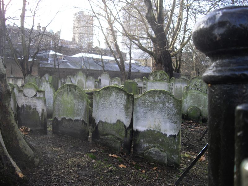
Walls, railings and gates bounding Bunhill Fields Burial Ground, of 1868 (east side) and 1878 (west side), and a late C18 or early C19 wall with numerical plaques (south side).
EASTERN BOUNDARY: (TQ3277882245) a low coped wall of dressed stone, approximately 65 metres long, punctuated by piers and topped with railings. Five granite piers, square in plan and coped and gabled in a Greek Revival manner, bearing incised and gilded inscriptions in capital letters. The two piers flanking the iron gates record the history of the burial ground, in part echoing an earlier inscription on C17 gate piers recorded by Strype in 1720. The piers tell of the burial ground's foundation in 1665, closure for burials in 1852, and its opening as a public garden in 1869; further text was inscribed in 1964 recounting the restoration of Bunhill Fields after the Second World War. The other three piers give the names of some of the luminaries buried at Bunhill Fields, the majority of whose tombs survive and are listed (q.v.). The railings have spearhead finials and are gathered at intervals in clusters of eight to form additional piers. There is a gate at the southern end of the run. A small section of railings and wall to the north of the final pier is modern, but built to match the original and bounds a small pocket of land added to Bunhill Fields at the start of the C21.
SOUTHERN BOUNDARY: (TQ3265782203) a stock brick wall approximately 120 metres long, marking the boundary between Bunhill Fields and the Honourable Artillery Company buildings to the south. It runs about two-thirds of the width of the site, from Bunhill Row in the west as far as the east wall of Armoury House, where it is replaced by a short length of modern wall, and then by modern railings. There are various changes of height and alignment, most markedly towards the western end, midway along the flank of 33 Bunhill Row, where the wall drops in height by about a third. The lower end section (corresponding to the garden wall of the former St Paul's vicarage) has shallow brick buttresses and a modern concrete coping. Attached to the wall, running east to west, is a series of cast-iron numbered plaques that mark the north-south rows in which the tombs are arranged. Many have now been lost; the surviving sequence begins at at 17, and then runs 18, 19... 23... 26... 28... 30... 32... 35, 36, 37, 38... 40, 41, 42, 43... 46, 47... 49, 50, 51, 52, 5[3]... 65, 66, 67, 68, 69.
WESTERN BOUNDARY: (TQ3261682221) a low brown brick wall in Flemish bond, approximately 65 metres long, surmounted by fourteen square brick piers with moulded stone cappings. Iron railings with bracketed supports and spear finials, with gates in the sixth bay from the north.
HISTORY: Bunhill Fields was first enclosed as a burial ground in 1665. Thanks to its location just outside the City boundary, and its independence from any Established place of worship, it became London's principal Nonconformist cemetery, the burial place of John Bunyan, Daniel Defoe, William Blake and other leading religious and intellectual figures. It was closed for burials in 1853, laid out as a public park in 1869, and re-landscaped following war damage by Bridgewater and Shepheard in 1964-5.
REASONS FOR DESIGNATION: The eastern and western walls, railings and gates and the southern wall to Bunhill Fields Burial Ground are designated at Grade II for the following principal reasons:
* Historic interest: they mark the ancient boundaries of Bunhill Fields Burial Ground, which were established in 1665 and took their present form in 1700;
* Architectural interest: the eastern boundary is a handsome Greek Revival style structure of the mid-C19 phase in Bunhill Fields' history, when the burial ground became a public garden;
* Evidential value: the south wall's characterful cast-iron plaques indicate a system of numbered rows formerly used to locate individual burial plots;
* Group value: the boundary walls are an essential part of the setting of this Grade I-registered landscape, the pre-eminent graveyard for Nonconformists in England, and the many listed tombs therein.
External links are from the relevant listing authority and, where applicable, Wikidata. Wikidata IDs may be related buildings as well as this specific building. If you want to add or update a link, you will need to do so by editing the Wikidata entry.


Other nearby listed buildings
