Approximate Location Map
Large Map »
Latitude: 52.1866 / 52°11'11"N
Longitude: 0.9958 / 0°59'44"E
OS Eastings: 604884
OS Northings: 258490
OS Grid: TM048584
Mapcode National: GBR SJM.SP8
Mapcode Global: VHKDP.69SM
Plus Code: 9F425XPW+J8
Entry Name: 13, MARRIOT'S WALK (See details for further address information)
Listing Date: 28 July 1950
Grade: II
Source: Historic England
Source ID: 1195869
English Heritage Legacy ID: 384610
ID on this website: 101195869
Location: Stowmarket, Mid Suffolk, IP14
County: Suffolk
District: Mid Suffolk
Civil Parish: Stowmarket
Built-Up Area: Stowmarket
Traditional County: Suffolk
Lieutenancy Area (Ceremonial County): Suffolk
Church of England Parish: Stowmarket St Peter and St Mary
Church of England Diocese: St.Edmundsbury and Ipswich
Tagged with: Building
STOWMARKET
TM0458 KENSINGTON ROAD
614-1/4/83 (North side)
28/07/50 No.1
GV II
Includes: No.13 MARRIOTT'S WALK.
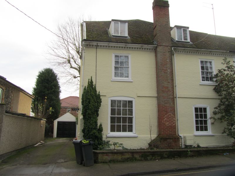
House, now divided into 2 properties. c1760. Colourwashed
brick under plain tile and slate roofs. South front forms
entrance to No.1 Kensington Road. 2 storeys; 3-window front.
Central 6-panelled door under a shallow 5-vaned fanlight.
Reeded quarter-columns to doorcase. One 8/8 sash right and
left under segmental heads. One 6/6 sash over door flanked by
one 8/8 sash right and left. Modillion eaves cornice. Hipped
roof. West return of 3 bays. Platband at first floor and C20
external stack left of centre. Three 6/6 sashes each floor, 2
of which are C20. One C20 roundel to ground floor. 3
flat-topped dormers. Stacks on rear roof slopes. To rear of
No.13 Marriott's Walk is a 3-storey early C19 hipped extension
occupying the angle of an otherwise L-shaped plan: sashes and
slate roof; external stacks north and south.
Listing NGR: TM0488458490
External links are from the relevant listing authority and, where applicable, Wikidata. Wikidata IDs may be related buildings as well as this specific building. If you want to add or update a link, you will need to do so by editing the Wikidata entry.


Other nearby listed buildings
