Approximate Location Map
Large Map »
Latitude: 53.7365 / 53°44'11"N
Longitude: -2.9603 / 2°57'37"W
OS Eastings: 336752
OS Northings: 427102
OS Grid: SD367271
Mapcode National: GBR 7TR7.XB
Mapcode Global: WH85P.HBKX
Plus Code: 9C5VP2PQ+HV
Entry Name: 2-10, Bath Street
Listing Date: 13 January 1971
Grade: II
Source: Historic England
Source ID: 1196396
English Heritage Legacy ID: 385234
ID on this website: 101196396
Location: Lytham, Fylde, Lancashire, FY8
County: Lancashire
District: Fylde
Electoral Ward/Division: Clifton
Parish: Non Civil Parish
Built-Up Area: Lytham St Anne's
Traditional County: Lancashire
Lieutenancy Area (Ceremonial County): Lancashire
Church of England Parish: Lytham St John the Divine
Church of England Diocese: Blackburn
Tagged with: Building
SD3627SE
621-1/6/12
LYTHAM ST ANNES, Lytham,
BATH STREET (East side),
Nos.2-10 (Even)
13/01/71
GV II
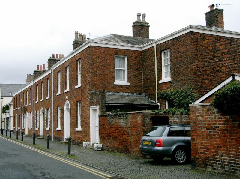
Terraced row of 4 small town houses plus end annex (No.2).
c.1830; altered. Red brick in Flemish bond, with sandstone
dressings and hipped slate roof. Double-depth plan, Nos 4-10
all double-fronted and No.10 set back at the right-hand end,
with various individual back extensions. Two storeys,
3+3+3+3+1 windows, Nos 4-10 all symmetrical. Each of these has
2 steps up to a central round-headed doorway with moulded
stone architrave and fanlight with radiating tracery (varied),
a 4-panel door to No.4 but all the others altered, and sashed
windows with raised stone sills and gauged brick heads, some
with restored joinery and all without glazing bars except
those to the right at No.4 which have 12 panes. No.2, set back
at the right-hand end, has a projected single-storey porch
flush with the main range, with a square-headed doorway and
6-panel door, and at first floor behind this a sashed window
with glazing bars. Ridge chimneys. The row forms a group with
the pebble pavement in front of it, with the former Methodist
chapel (q.v.) and Nos 1 and 3, and No 9 opposite (q.v.).
Listing NGR: SD3675227102
External links are from the relevant listing authority and, where applicable, Wikidata. Wikidata IDs may be related buildings as well as this specific building. If you want to add or update a link, you will need to do so by editing the Wikidata entry.


Other nearby listed buildings
