Approximate Location Map
Large Map »
Latitude: 52.2045 / 52°12'16"N
Longitude: -3.038 / 3°2'16"W
OS Eastings: 329158
OS Northings: 256755
OS Grid: SO291567
Mapcode National: GBR F4.3C1G
Mapcode Global: VH778.9V8F
Plus Code: 9C4R6X36+QQ
Entry Name: Cross in Churchyard of Church of St Mary
Listing Date: 31 December 1993
Grade: II
Source: Historic England
Source ID: 1196559
English Heritage Legacy ID: 385798
ID on this website: 101196559
Location: St Mary's Church, Newton, County of Herefordshire, HR5
County: County of Herefordshire
Civil Parish: Kington
Built-Up Area: Kington
Traditional County: Herefordshire
Lieutenancy Area (Ceremonial County): Herefordshire
Church of England Parish: Kington
Church of England Diocese: Hereford
Tagged with: Monumental cross
KINGTON
SO2956
643-1/1/54
CHURCH ROAD
(North West side)
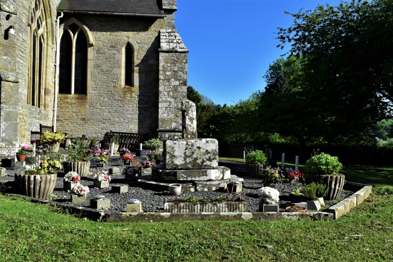
Cross in churchyard of Church of St
Mary
GV
II
Cross. Medieval. Sandstone. Stump of shaft, with
pyramid-stopped chamfers, on square base with tabernacle.
Listing NGR: SO2915856755
External links are from the relevant listing authority and, where applicable, Wikidata. Wikidata IDs may be related buildings as well as this specific building. If you want to add or update a link, you will need to do so by editing the Wikidata entry.


Other nearby listed buildings
