Approximate Location Map
Large Map »
Latitude: 51.5069 / 51°30'24"N
Longitude: -2.6308 / 2°37'51"W
OS Eastings: 356313
OS Northings: 178850
OS Grid: ST563788
Mapcode National: GBR JP.J6Y2
Mapcode Global: VH88F.CD15
Plus Code: 9C3VG949+QM
Entry Name: Village Hall
Listing Date: 20 March 1974
Last Amended: 30 December 1994
Grade: II
Source: Historic England
Source ID: 1202073
English Heritage Legacy ID: 379157
ID on this website: 101202073
Location: Henbury, Bristol, BS10
County: City of Bristol
Electoral Ward/Division: Henbury and Brentry
Parish: Non Civil Parish
Built-Up Area: Bristol
Traditional County: Gloucestershire
Lieutenancy Area (Ceremonial County): Bristol
Church of England Parish: Henbury
Church of England Diocese: Bristol
Tagged with: Village hall
BRISTOL
ST5678NW CHURCH LANE, Henbury
901-1/17/1337 (East side)
20/03/74 Village Hall
(Formerly Listed as:
CHURCH LANE
Henbury School)
GV II
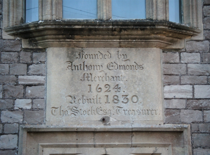
School, now village hall. 1830. By Thomas Rickman. Squared,
coursed Lias with limestone dressings and slate roof. Central
hall with cross-wing at each end. Tudor Revival style. 2
storeys; 3-window range. Central Tudor-arched door in label
mould with a ribbed door, beneath a panel inscribed FOUNDED
1624/ BY ANTHONY EDMONDS/ REBUILT 1830; paired lancet
left-hand windows in a label mould, and similar single-light
windows to the right; above the door is a shallow canted oriel
with ogee cinquefoil-headed lights and a crenellated parapet,
and a gabled dormer with a small chamfered window; octagonal
finials to the corners and to the dormer. INTERIOR: entrance
hall and flight of stairs to the right, with a hall behind.
HISTORICAL NOTE: the Charity School stood on the site from
1601 until the current building replaced it.
(Hallen and Henbury Women's Institute: A Guide to Henbury:
Bristol: 1970-: 15).
Listing NGR: ST5631378850
External links are from the relevant listing authority and, where applicable, Wikidata. Wikidata IDs may be related buildings as well as this specific building. If you want to add or update a link, you will need to do so by editing the Wikidata entry.


Other nearby listed buildings
