Approximate Location Map
Large Map »
Latitude: 51.4502 / 51°27'0"N
Longitude: -2.5962 / 2°35'46"W
OS Eastings: 358668
OS Northings: 172524
OS Grid: ST586725
Mapcode National: GBR C7L.TZ
Mapcode Global: VH88M.YTC5
Plus Code: 9C3VFC23+3G
Entry Name: 49 and 50, Queen Square
Listing Date: 8 January 1959
Last Amended: 30 December 1994
Grade: II
Source: Historic England
Source ID: 1202471
English Heritage Legacy ID: 380256
ID on this website: 101202471
Location: Bristol, BS1
County: City of Bristol
Electoral Ward/Division: Central
Parish: Non Civil Parish
Built-Up Area: Bristol
Traditional County: Gloucestershire
Lieutenancy Area (Ceremonial County): Bristol
Church of England Parish: Bristol St Stephen with St James and St John the Baptist with St Michael and St George
Church of England Diocese: Bristol
Tagged with: Building
BRISTOL
ST5872NE QUEEN SQUARE
901-1/16/208 (West side)
08/01/59 Nos.49 AND 50
(Formerly Listed as:
QUEEN SQUARE
(West side)
Nos.46-55 (Consecutive))
GV II
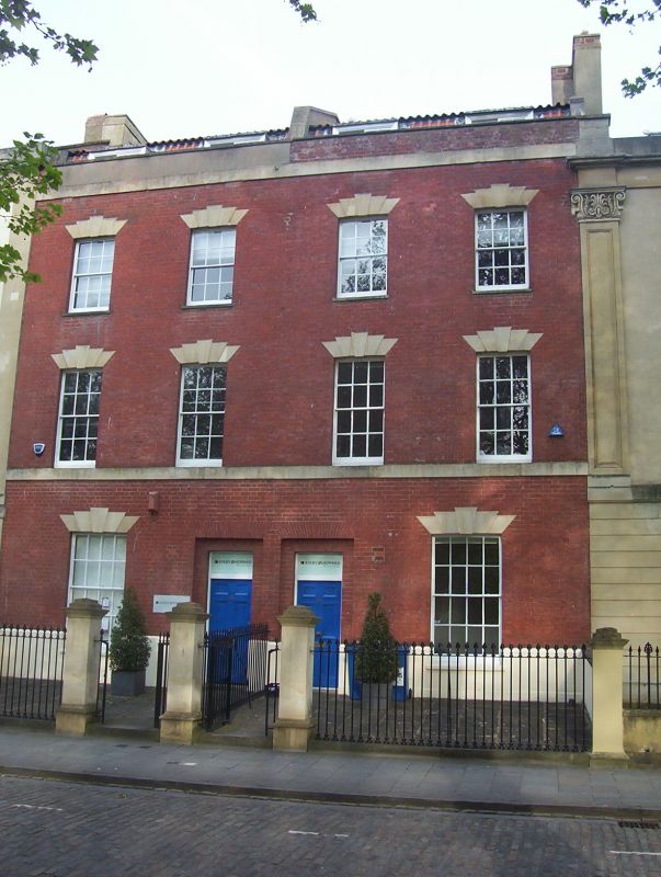
Pair of attached houses. c1780. Brick with limestone
dressings, party wall stacks and a pantile mansard roof.
Double-depth plan. Each of 3 storeys, attic and basement;
2-window range. A symmetrical pair has a first-floor sill
band, cornice band and parapet; paired doorways to the middle,
set in shallow recesses, have rubbed brick flat arches with
cambered heads, plate-glass overlights and 6-panel doors.
Cambered heads with 5 stepped voussoirs to single ground-floor
8/8-pane sashes, and upper 6/6-pane sashes, with 2 dormers
each.
INTERIOR: entrance hall with panelled semicircular arch to a
rear dogleg stair with stick balusters, curtail and wreathed
rail; cornice with palmettes in the corners; fireplaces,
6-panel doors and panelled shutters. Queen Square was built
between 1701 and 1727. Much of the W side was rebuilt after
the Reform Bill riots of 1831.
(Gomme A: Street Index of Buildings of Architectural or
Historic Interest: 50; Gomme A, Jenner M and Little B:
Bristol, An Architectural History: Bristol: 1979-: 94).
Listing NGR: ST5866872524
External links are from the relevant listing authority and, where applicable, Wikidata. Wikidata IDs may be related buildings as well as this specific building. If you want to add or update a link, you will need to do so by editing the Wikidata entry.


Other nearby listed buildings
