Approximate Location Map
Large Map »
Latitude: 50.5591 / 50°33'32"N
Longitude: -2.4418 / 2°26'30"W
OS Eastings: 368798
OS Northings: 73355
OS Grid: SY687733
Mapcode National: GBR PZ.2SRG
Mapcode Global: FRA 57SL.6K1
Plus Code: 9C2VHH55+J7
Entry Name: Royal Portland Arms
Listing Date: 21 September 1978
Grade: II
Source: Historic England
Source ID: 1203086
English Heritage Legacy ID: 381944
ID on this website: 101203086
Location: Fortuneswell, Dorset, DT5
County: Dorset
Civil Parish: Portland
Built-Up Area: Fortuneswell
Traditional County: Dorset
Lieutenancy Area (Ceremonial County): Dorset
Church of England Parish: Portland All Saints
Church of England Diocese: Salisbury
Tagged with: Pub
PORTLAND
SY6873 FORTUNESWELL, Fortuneswell
969-1/3/95 (North East side)
21/09/78 No.40
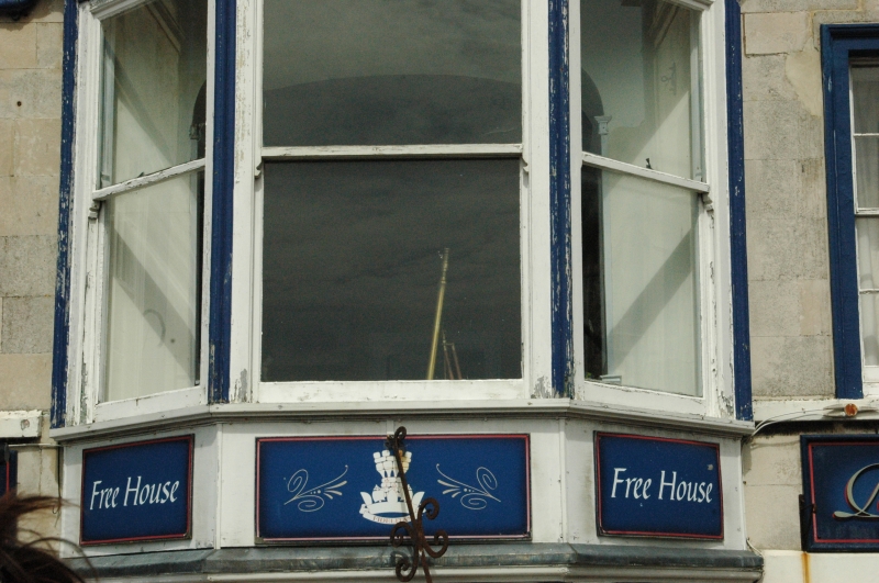
Royal Portland Arms
II
Inn. Mid C19, possibly incorporating some earlier fabric.
Ashlar, slate roofs. A lofty symmetrical frontage set flush
with adjoining buildings, and having two deep gabled wings to
back, cutting into ground slope. Two storeys and attic,
3-windowed. Three gabled dormers immediately above moulded
stone cornice, small plain sashes under raised copings on
kneelers. At first floor a bold oriel to flat roof and on
shaped wooden brackets, large plate glass sasshes, moulded
cornice, and moulded base under skirt; each side a good
12-pane sash in moulded stone architrave and cill band. Ground
floor has large nearly square openings with plate glass under
2-pane upper light, in moulded stone surround with small
keystone. Central panelled C19 door in moulded architrave
under plain transom light, on 2 stone steps. Plinth, band
above door height, entablature and blocking course. To each
gable a large stone stack with capping, coped verges; the roof
surface projects boldly between and at ends of dormers. The
layout and proportions suggest a late C18 front which has been
modified and raised.
Listing NGR: SY6879873355
External links are from the relevant listing authority and, where applicable, Wikidata. Wikidata IDs may be related buildings as well as this specific building. If you want to add or update a link, you will need to do so by editing the Wikidata entry.


Other nearby listed buildings
