Approximate Location Map
Large Map »
Latitude: 53.3983 / 53°23'53"N
Longitude: -1.7764 / 1°46'35"W
OS Eastings: 414962
OS Northings: 389071
OS Grid: SK149890
Mapcode National: GBR JY14.6J
Mapcode Global: WHCC6.PV86
Plus Code: 9C5W96XF+8C
Entry Name: Rowlee Bridge
Listing Date: 21 April 1967
Grade: II
Source: Historic England
Source ID: 1203883
English Heritage Legacy ID: 82161
ID on this website: 101203883
Location: High Peak, Derbyshire, S33
County: Derbyshire
District: High Peak
Civil Parish: Hope Woodlands
Traditional County: Derbyshire
Lieutenancy Area (Ceremonial County): Derbyshire
Church of England Parish: Bamford and Derwent St John the Baptist
Church of England Diocese: Derby
Tagged with: Bridge
SK 18 NW PARISH OF HOPE WOODLANDS OFF SNAKE ROAD
13/17 (South Side)
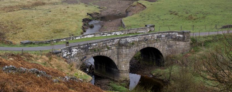
Rowlee Bridge
21.4.67 II
Bridge c 1830 coursed squared gritstone. Two segmental arches with stone
voussoirs. Flat string band at the springing of the arches and above the
arches. Semi-circular cutwater on each side. Curved wing walls. Stone copings.
Listing NGR: SK1496289071
External links are from the relevant listing authority and, where applicable, Wikidata. Wikidata IDs may be related buildings as well as this specific building. If you want to add or update a link, you will need to do so by editing the Wikidata entry.


Other nearby listed buildings
