Approximate Location Map
Large Map »
Latitude: 51.4524 / 51°27'8"N
Longitude: -2.6042 / 2°36'14"W
OS Eastings: 358115
OS Northings: 172778
OS Grid: ST581727
Mapcode National: GBR C6L.05
Mapcode Global: VH88M.TR4F
Plus Code: 9C3VF92W+X8
Entry Name: Brandon Cottage and Attached Rubble Wall and Doorway
Listing Date: 8 January 1959
Last Amended: 30 December 1994
Grade: II
Source: Historic England
Source ID: 1204229
English Heritage Legacy ID: 378977
ID on this website: 101204229
Location: Bristol, BS1
County: City of Bristol
Electoral Ward/Division: Hotwells and Harbourside
Parish: Non Civil Parish
Built-Up Area: Bristol
Traditional County: Gloucestershire
Lieutenancy Area (Ceremonial County): Bristol
Church of England Parish: Bristol St Stephen with St James and St John the Baptist with St Michael and St George
Church of England Diocese: Bristol
Tagged with: Cottage
BRISTOL
ST5872NW BRANDON STEEP
901-1/15/20 (South East side)
08/01/59 Nos.1 AND 2
Brandon Cottage and attached rubble
wall and doorway
(Formerly Listed as:
BRANDON STEEP
Brandon Cottage)
II
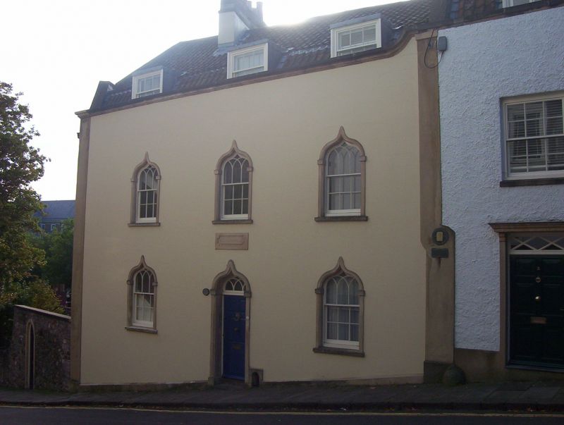
Attached house. Late C18-early C19. Render and roughcast with
limestone dressings, ridge stacks and pantile mansard roof,
hipped to the left. Double-depth plan. Gothick style. 2
storeys, attic and basement; 3-window range. A symmetrical
front has pilaster strips to a moulded coping ramped up to the
right. Door and windows have ogee-headed surrounds, the
doorway with imposts and key, interlacing fanlight and 6-panel
door. Windows with interlacing heads to 3/6-pane sashes. Three
C20 dormers. A panel over the door is inscribed BRANDON
COTTAGE. INTERIOR not inspected, but noted as having a
left-hand stair against the front windows. SUBSIDIARY
FEATURES: attached Pennant rubble wall with a pointed-arched
doorway with key and imposts, extends approx 20m to NE.
(Gomme A: Street Index of Buildings of Architectural or
Historic Interest: 8).
Listing NGR: ST5811572778
External links are from the relevant listing authority and, where applicable, Wikidata. Wikidata IDs may be related buildings as well as this specific building. If you want to add or update a link, you will need to do so by editing the Wikidata entry.


Other nearby listed buildings
