Approximate Location Map
Large Map »
Latitude: 54.2965 / 54°17'47"N
Longitude: -2.8476 / 2°50'51"W
OS Eastings: 344933
OS Northings: 489318
OS Grid: SD449893
Mapcode National: GBR 8LKR.9L
Mapcode Global: WH831.788K
Plus Code: 9C6V75W2+JX
Entry Name: Limekiln Approximately 150 Metres North West of Row Farm
Listing Date: 3 April 1989
Grade: II
Source: Historic England
Source ID: 1205027
English Heritage Legacy ID: 77110
ID on this website: 101205027
Location: Row, Westmorland and Furness, Cumbria, LA8
County: Cumbria
District: South Lakeland
Civil Parish: Crosthwaite and Lyth
Traditional County: Westmorland
Lieutenancy Area (Ceremonial County): Cumbria
Church of England Parish: Crosthwaite St Mary
Church of England Diocese: Carlisle
Tagged with: Lime kiln
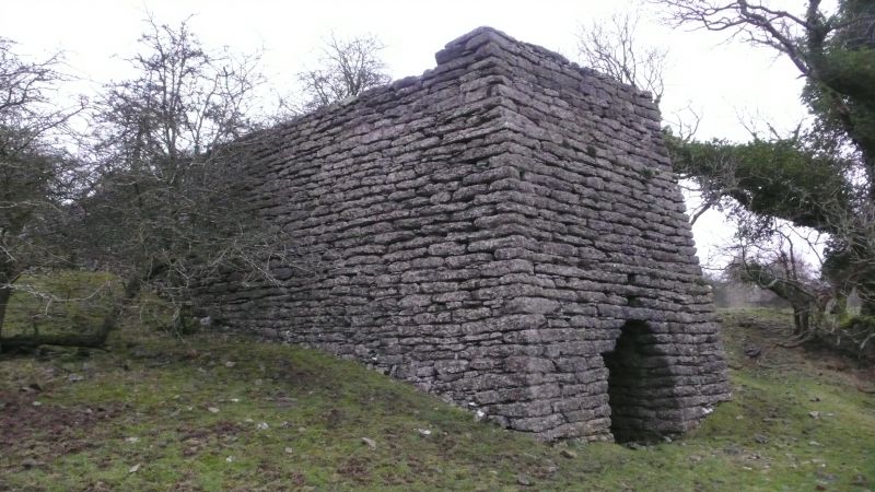
CROSTHWAITE AND LYTH LYTH
SD 48 NW
3/22 Limekiln approx. 150m
north-west of Row
Farm
II
Limekiln. Probably C19. Dressed stone. Large rectangular structure has
segmental-headed fire hole to south. Charge hole blocked. A good example.
Listing NGR: SD4493389318
External links are from the relevant listing authority and, where applicable, Wikidata. Wikidata IDs may be related buildings as well as this specific building. If you want to add or update a link, you will need to do so by editing the Wikidata entry.


Other nearby listed buildings
