Approximate Location Map
Large Map »
Latitude: 51.7167 / 51°42'59"N
Longitude: -1.965 / 1°57'54"W
OS Eastings: 402511
OS Northings: 201992
OS Grid: SP025019
Mapcode National: GBR 3QY.80R
Mapcode Global: VHB2Q.W3JV
Plus Code: 9C3WP28M+MX
Entry Name: Dyer Lodge
Listing Date: 23 July 1971
Grade: II
Source: Historic England
Source ID: 1205894
English Heritage Legacy ID: 365275
ID on this website: 101205894
Location: Cirencester, Cotswold, Gloucestershire, GL7
County: Gloucestershire
District: Cotswold
Civil Parish: Cirencester
Built-Up Area: Cirencester
Traditional County: Gloucestershire
Lieutenancy Area (Ceremonial County): Gloucestershire
Church of England Parish: Cirencester St John the Baptist
Church of England Diocese: Gloucester
Tagged with: Gatehouse
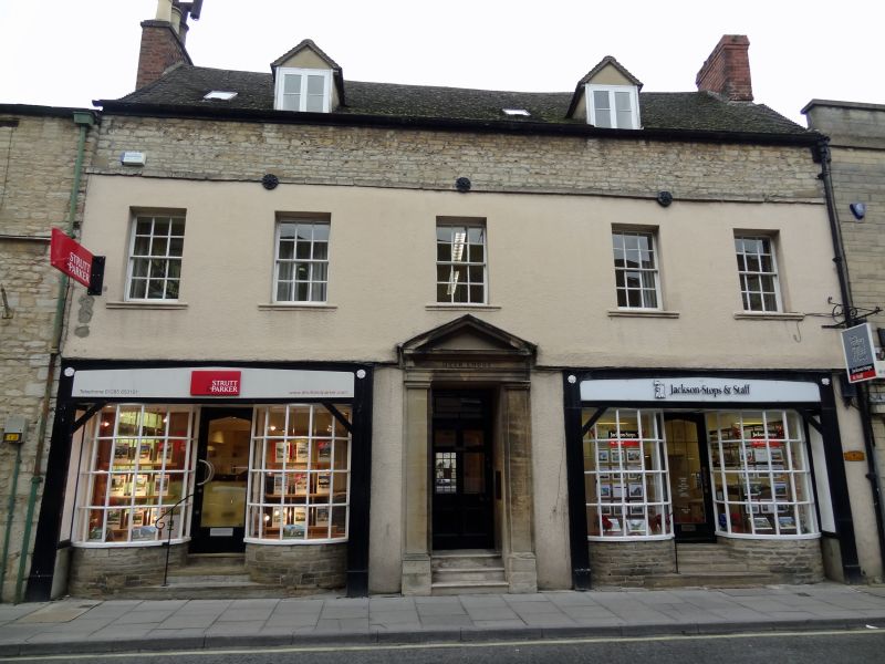
CIRENCESTER
SP0201 DYER STREET
578-1/6/136 (North side)
23/07/71 Nos.15 AND 17
Dyer Lodge
GV II
House, now shop. Early C18, possibly with earlier origins, and
with C20 alterations. Render and coursed squared limestone
rubble to front; concrete tile roof; C19 brick right-end
stack. 2 storeys and attic; 5-window range. First floor has
five 6/6-pane sashes in plain reveals with moulded stone
cills, now also coated in render. Ground floor has pair of
matching C20 shopfronts; flat unmoulded timber surrounds have
recessed fascia panels with Tudor arched heads; applied Tudor
roses in spandrels. 2 recessed 6x4-pane bow windows on coursed
squared rubble bases flank stone steps up to central glazed
door with leaded glazed panel with Tudor-arched head.
Pedimented Doric ashlar doorcase to centre; 6-panel door now
with upper 4 panels glazed and simple overlight. Band course
over first floor; exposed rubble above to eaves. Two gabled
dormers with 2-light timber casements. Two small C20
rooflights. Two large gabled wings, probably contemporary, to
rear. INTERIOR not inspected.
Listing NGR: SP0251101992
External links are from the relevant listing authority and, where applicable, Wikidata. Wikidata IDs may be related buildings as well as this specific building. If you want to add or update a link, you will need to do so by editing the Wikidata entry.


Other nearby listed buildings
