Approximate Location Map
Large Map »
Latitude: 52.9665 / 52°57'59"N
Longitude: -1.358 / 1°21'28"W
OS Eastings: 443214
OS Northings: 341211
OS Grid: SK432412
Mapcode National: GBR 7FY.5GB
Mapcode Global: WHDGP.3PLN
Plus Code: 9C4WXJ8R+JQ
Entry Name: Village Hall
Listing Date: 28 November 1974
Last Amended: 6 November 1986
Grade: II
Source: Historic England
Source ID: 1206126
English Heritage Legacy ID: 352309
ID on this website: 101206126
Location: West Hallam, Erewash, Derbyshire, DE7
County: Derbyshire
District: Erewash
Civil Parish: West Hallam
Built-Up Area: West Hallam
Traditional County: Derbyshire
Lieutenancy Area (Ceremonial County): Derbyshire
Church of England Parish: West Hallam St Wilfred
Church of England Diocese: Derby
Tagged with: Village hall
PARISH OF WEST HALLAM THE VILLAGE
SK 44 SW
2/106 (South Side)
Village Hall
28.11.74 (formerly listed
as Infant school)
GV II
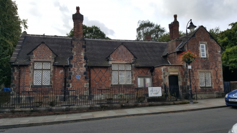
School, now village hall. Dated 1852 and built by the Scargill
Trust. Red brick with blue brick diaper work and gritstone
dressings. Plain and fishscale tile roofs. Stone coped gables.
Diamond plan lateral brick stacks, one with external chimney
breast. Two stacks in the pitch of the roof. Single storey.
Flush stone quoins. Chamfered stone plinth. North elevation of
three bays. Projecting gabled bay to right has a 2-light
chamfered mullion window to the ground floor with cast iron
diamond pane casements. Single light window above with
chamfered surround and plain casement. To the left in the
extruded angle, a square porch, with Tudor arched doorway with
chamfered surround and panelled door. Stone plaque above and
coped parapet. To the left, a 3-light and a 2-light recessed
and chamfered, mullioned and transomed window, each in a gabled
half dormer and with cast iron diamond casement lights. These
two windows flank a projecting chimney breast with two set-offs
on either flank. Low coped walls and railings attached to
north.
Listing NGR: SK4321441211
External links are from the relevant listing authority and, where applicable, Wikidata. Wikidata IDs may be related buildings as well as this specific building. If you want to add or update a link, you will need to do so by editing the Wikidata entry.


Other nearby listed buildings
