Approximate Location Map
Large Map »
Latitude: 53.259 / 53°15'32"N
Longitude: -2.1351 / 2°8'6"W
OS Eastings: 391087
OS Northings: 373559
OS Grid: SJ910735
Mapcode National: GBR FZJR.KG
Mapcode Global: WHBBP.5BKY
Plus Code: 9C5V7V57+HX
Entry Name: Crompton Road Mill
Listing Date: 28 October 1994
Grade: II
Source: Historic England
Source ID: 1206907
English Heritage Legacy ID: 390974
ID on this website: 101206907
Location: Macclesfield, Cheshire East, Cheshire, SK11
County: Cheshire East
Civil Parish: Macclesfield
Built-Up Area: Macclesfield
Traditional County: Cheshire
Lieutenancy Area (Ceremonial County): Cheshire
Church of England Parish: All Saints Macclesfield
Church of England Diocese: Chester
Tagged with: Spinning mill
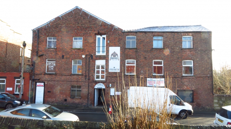
MACCLESFIELD
SJ9173NW CROMPTON ROAD
886-1/9/74 (East side)
Crompton Road Mill
GV II
Silk weaving and cotton spinning mill. c1825, with late C19
additions. Brick with slate roof replaced by corrugated
sheeting. Built on a steeply sloping site, 3-storeyed in wing
facing street, 5-storeyed in main range parallel to street.
Main range of 12 bays, with 3-bay wing at one end facing
street and adjoining gable of main range. Gable refronted (or
mill extended) later C19. Entrance in the gable, a
round-arched doorway to ground floor, and loading doors to
upper floors. Hoist projects over upper loading door. 2
windows to left, and inserted lower doorway. 3 windows in the
wing. Windows all transoms with flat-arched heads. Many
original small-paned fixed light windows survive in the main
range, although some have been renewed with top opening
lights, all in original openings with flat-arched heads. Privy
tower projects from the south-east angle.
INTERIOR: internal structure has single row of slim cast-iron
columns carrying timber beams, with timber roof structure.
Formerly steam-powered, the engine house (which does not
survive intact) was to the east of the mill building.
(Fricker, Calladine et al: Macclesfield Mills Survey).
Listing NGR: SJ9108773559
External links are from the relevant listing authority and, where applicable, Wikidata. Wikidata IDs may be related buildings as well as this specific building. If you want to add or update a link, you will need to do so by editing the Wikidata entry.


Other nearby listed buildings
