Approximate Location Map
Large Map »
Latitude: 54.9077 / 54°54'27"N
Longitude: -1.3803 / 1°22'48"W
OS Eastings: 439832
OS Northings: 557178
OS Grid: NZ398571
Mapcode National: GBR VCY.49
Mapcode Global: WHD55.RXX1
Plus Code: 9C6WWJ59+3V
Entry Name: Register Buildings
Listing Date: 10 November 1978
Last Amended: 17 October 1994
Grade: II
Source: Historic England
Source ID: 1207091
English Heritage Legacy ID: 391484
ID on this website: 101207091
Location: Sunderland, Tyne and Wear, SR1
County: Sunderland
Electoral Ward/Division: Hendon
Parish: Non Civil Parish
Built-Up Area: Sunderland
Traditional County: Durham
Lieutenancy Area (Ceremonial County): Tyne and Wear
Church of England Parish: Hendon
Church of England Diocese: Durham
Tagged with: Building
SUNDERLAND
NZ3957SE HIGH STREET WEST
920-1/18/105 (North side)
10/11/78 Nos.114-118 (Consecutive)
Register Buildings
(Formerly Listed as:
HIGH STREET WEST
(North side)
Nos.114-118 (Consecutive))
GV II
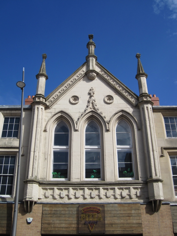
Offices for Registrar and Poor Law Guardians. 1856. By Thomas
Moore. Ashlar with Welsh slate roof. Gothic style. 3:2:3
storeys, 4:3:4 windows. Altered ground floor has C20 shops.
Central gabled section has 3 lancets under dripstring with
central crocketed ogee; pierced quatrefoils flank finial.
Pilasters defining gable have cusped panels and rise to
octagonal pinnacles and spirelets with Tudor-flower finials.
Gable has pierced panelled parapet with intermediate spirelets
and finials. Flanking sections have label moulds and splayed
reveals to sashes with glazing bars, some renewed; 4 right
bays have original fine glazing bars to most windows; one wide
C20 window inserted. Moulded gutter cornice.
(Corfe T: The Buildings of Sunderland 1814-1914.: Newcastle
upon Tyne: 1983-: 15, 20).
Listing NGR: NZ3983257178
External links are from the relevant listing authority and, where applicable, Wikidata. Wikidata IDs may be related buildings as well as this specific building. If you want to add or update a link, you will need to do so by editing the Wikidata entry.


Other nearby listed buildings
