Approximate Location Map
Large Map »
Latitude: 54.9045 / 54°54'16"N
Longitude: -1.3906 / 1°23'26"W
OS Eastings: 439173
OS Northings: 556811
OS Grid: NZ391568
Mapcode National: GBR VBD.25
Mapcode Global: WHD55.MZ0J
Plus Code: 9C6WWJ35+QQ
Entry Name: Wall behind St Mary's Building at the University of Sunderland
Listing Date: 17 October 1994
Grade: II
Source: Historic England
Source ID: 1207095
English Heritage Legacy ID: 391495
ID on this website: 101207095
Location: Thornhill Cresecent, Sunderland, Tyne and Wear, SR1
County: Sunderland
Electoral Ward/Division: Millfield
Parish: Non Civil Parish
Built-Up Area: Sunderland
Traditional County: Durham
Lieutenancy Area (Ceremonial County): Tyne and Wear
Church of England Parish: Millfield St Mark
Church of England Diocese: Durham
Tagged with: Wall
SUNDERLAND
NZ3956NW HIND STREET
920-1/19/115 (West side (off))
Wall Behind St Mary's Building at
The University of Sunderland
GV II
(Formerly Listed as Wall behind St Mary's Building of
Sunderland Polytechnic)
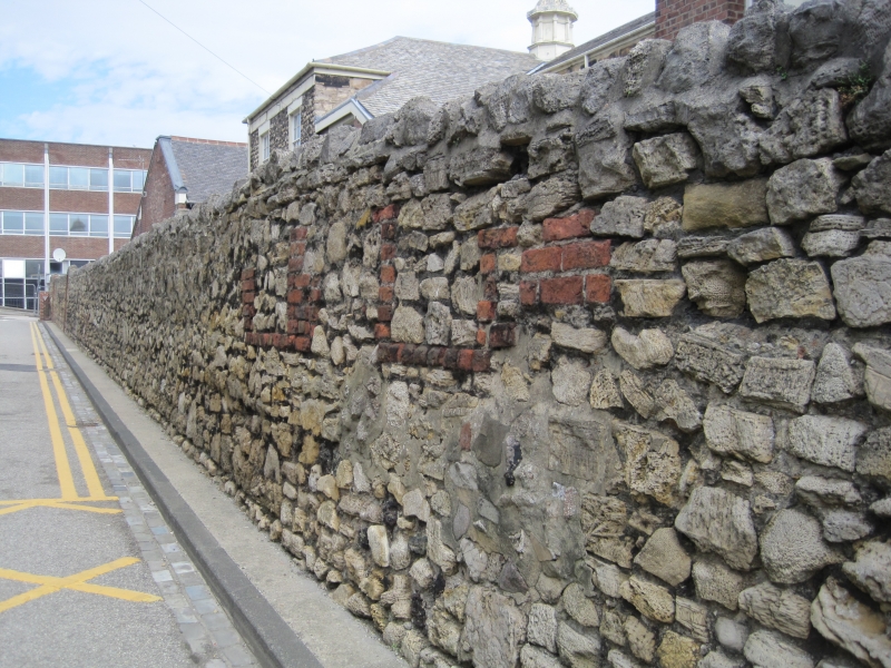
Wall enclosing yard of infirmary, at the time of Listing St Mary's
Building of Sunderland Polytechnic (qv). c1822 with C20 alterations.
Rubble limestone with roughly rounded coping; brick blocking
to doorway. High wall formerly enclosing yard to infirmary
continues from S, along W and part of N boundary. Brick
blocking to former door on W; small hatches have wood doors
and were probably formerly for delivery of coal. Central
section altered slightly, probably when Edinburgh Building of
Polytechnic, to S was constructed c1960 (not listed).
Included for group value.
Listing NGR: NZ3917356811
External links are from the relevant listing authority and, where applicable, Wikidata. Wikidata IDs may be related buildings as well as this specific building. If you want to add or update a link, you will need to do so by editing the Wikidata entry.


Other nearby listed buildings
