Approximate Location Map
Large Map »
Latitude: 53.3298 / 53°19'47"N
Longitude: -2.8372 / 2°50'14"W
OS Eastings: 344338
OS Northings: 381755
OS Grid: SJ443817
Mapcode National: GBR 8YMY.K2
Mapcode Global: WH87P.DK5P
Plus Code: 9C5V85H7+W4
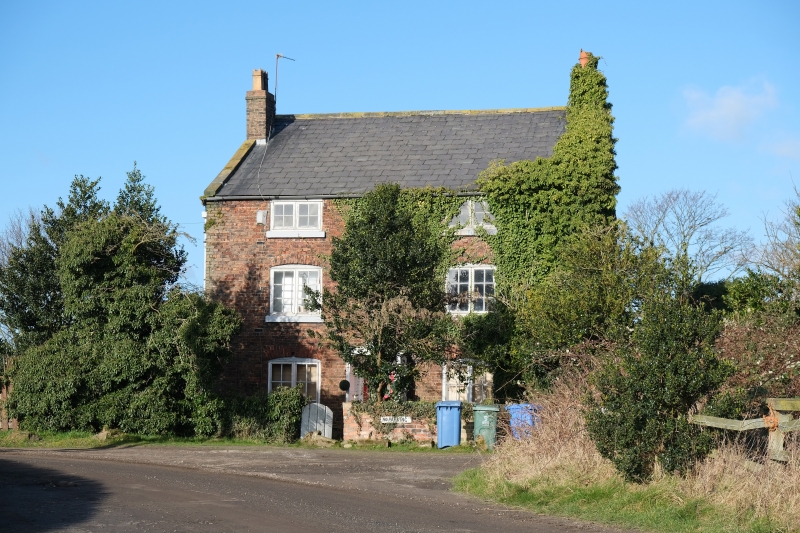
Entry Name: Yew Tree Farmhouse
Listing Date: 14 March 1975
Grade: II
Source: Historic England
Source ID: 1208621
English Heritage Legacy ID: 359180
ID on this website: 101208621
Location: Oglet, Liverpool, Merseyside, L24
County: Liverpool
Electoral Ward/Division: Speke-Garston
Parish: Non Civil Parish
Traditional County: Lancashire
Lieutenancy Area (Ceremonial County): Merseyside
Church of England Parish: Speke St Aidan
Church of England Diocese: Liverpool
Tagged with: Farmhouse
SJ 48 SW OGLET LANE
L24
10/840 Yew Tree
Farmhouse
14.3.75.
- II
Farmhouse. Early C19. Brick with stone dressings, slate
roof. 3 storeys, 2 bays. Windows have segmental heads and
small-paned casements. Central entrance has C20 timber
porch.
Listing NGR: SJ4433881755
External links are from the relevant listing authority and, where applicable, Wikidata. Wikidata IDs may be related buildings as well as this specific building. If you want to add or update a link, you will need to do so by editing the Wikidata entry.


Other nearby listed buildings
