Approximate Location Map
Large Map »
Latitude: 53.5582 / 53°33'29"N
Longitude: -2.8525 / 2°51'8"W
OS Eastings: 343627
OS Northings: 407183
OS Grid: SD436071
Mapcode National: GBR 8WJ9.76
Mapcode Global: WH86J.4TYK
Plus Code: 9C5VH45X+72
Entry Name: Church of St James
Listing Date: 11 August 1972
Grade: II
Source: Historic England
Source ID: 1210368
English Heritage Legacy ID: 386421
ID on this website: 101210368
Location: St James's Church, Westhead, West Lancashire, L40
County: Lancashire
District: West Lancashire
Electoral Ward/Division: Derby
Parish: Non Civil Parish
Traditional County: Lancashire
Lieutenancy Area (Ceremonial County): Lancashire
Church of England Parish: Westhead St James
Church of England Diocese: Liverpool
Tagged with: Church building
ORMSKIRK
SD40NW VICARAGE LANE, Westhead
663-1/4/192 (North side)
11/08/72 Church of St James
GV II
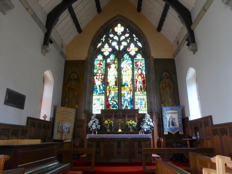
Church. 1851. By Sydney Smirke. Coursed squared sandstone,
stone slate roofs. Geometric style. Nave with south-west
steeple, south aisle under parallel roof, chancel with south
vestry. The 3-stage tower has diagonal buttresses, a weathered
plinth and sill-band, a moulded 2-centred arched south doorway
with set-in shafts, a trefoil to the 2nd stage, 2-light belfry
windows, and a broach spire with lucarnes on 2 levels. The
4-bay aisle has 2-centred arched windows each of 2 cusped
lights, with varied quatrefoils in the heads, and hoodmoulds
with figured stops; the north side of the nave has similar
windows, and a 3-light west window with geometrical tracery.
The 2-bay chancel has a large 4-light east window with
reticulated tracery. INTERIOR: 4-bay aisle arcade of short
cylindrical columns with moulded annular caps and 2-centred
double- chamfered arches; similar chancel arch; good stained
glass in east window. Forms group with lychgate (q.v.), and
with the Old Vicarage to the east (q.v.).
Listing NGR: SD4362707183
External links are from the relevant listing authority and, where applicable, Wikidata. Wikidata IDs may be related buildings as well as this specific building. If you want to add or update a link, you will need to do so by editing the Wikidata entry.


Other nearby listed buildings
