Approximate Location Map
Large Map »
Latitude: 51.4165 / 51°24'59"N
Longitude: -1.5147 / 1°30'52"W
OS Eastings: 433845
OS Northings: 168719
OS Grid: SU338687
Mapcode National: GBR 706.1W2
Mapcode Global: VHC1S.PNLH
Plus Code: 9C3WCF8P+H4
Entry Name: 1, HIGH STREET (See details for further address information)
Listing Date: 8 June 1984
Grade: II
Source: Historic England
Source ID: 1210558
English Heritage Legacy ID: 395171
ID on this website: 101210558
Location: Hungerford, West Berkshire, RG17
County: West Berkshire
Civil Parish: Hungerford
Built-Up Area: Hungerford
Traditional County: Berkshire
Lieutenancy Area (Ceremonial County): Berkshire
Church of England Parish: Hungerford with Denford
Church of England Diocese: Oxford
Tagged with: Building
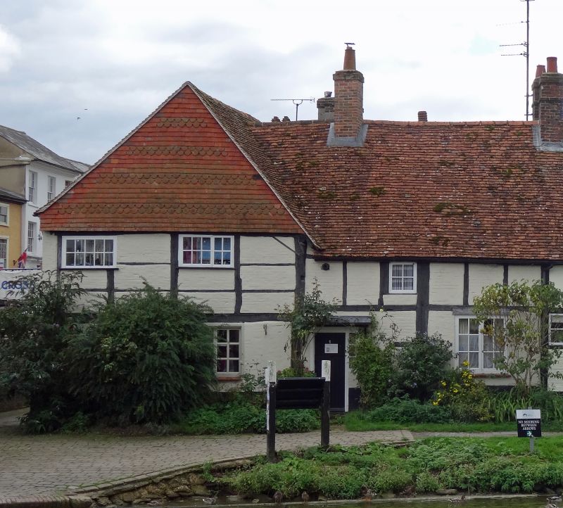
HUNGERFORD HIGH STREET
SU 3368
(West side)
18/22 No. 1
G.V. II
Includes No. 1 Canalside:
House. Late C16 with C18 re-fronting and C19 alterations. Tiled roof,
structural timber frame with painted brick front, dentil course to
eaves and band at first floor, tile hanging to gable and brick infill to
timber frame on canalside. L plan. 2 storeys. High Street elevation:
5 light and two 3-light C20 casements to left with insurance plaque between
first and second from left, square C19 oriel bay to right and door approached
by iron bridge; ground floor open entry with cambered head to left, C20
casements flanking central door and simple casement with cambered head to
right. Canalside elevation: gable to left with exposed timber framing at
first floor and brick ground floor, 2 irregular casements on first floor
and one to right of ground floor, building extends to right with pitched
roof at right angles to High Street, two short bays of exposed timber framing,
C20 door under flat hood to left of first bay and 2 light C19 casement in
second bay.
Listing NGR: SU3384568719
External links are from the relevant listing authority and, where applicable, Wikidata. Wikidata IDs may be related buildings as well as this specific building. If you want to add or update a link, you will need to do so by editing the Wikidata entry.


Other nearby listed buildings
