Approximate Location Map
Large Map »
Latitude: 50.2698 / 50°16'11"N
Longitude: -4.7847 / 4°47'4"W
OS Eastings: 201652
OS Northings: 44796
OS Grid: SX016447
Mapcode National: GBR ZY.S0K3
Mapcode Global: FRA 08V9.ZR6
Plus Code: 9C2Q7698+W4
Entry Name: Harbour Piers and Quays
Listing Date: 11 March 1974
Grade: II*
Source: Historic England
Source ID: 1210773
English Heritage Legacy ID: 395279
ID on this website: 101210773
Location: Trevarth Estate, Cornwall, PL26
County: Cornwall
Civil Parish: Mevagissey
Built-Up Area: Mevagissey
Traditional County: Cornwall
Lieutenancy Area (Ceremonial County): Cornwall
Church of England Parish: Mevagissey
Church of England Diocese: Truro
Tagged with: Wharf
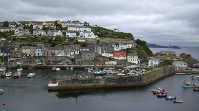
MEVAGISSEY
1.
1584A
Harbour piers and Quays
SX 04 NW 3/213
SX 04 SW 13/213
II*
2.
Stone built piers and quays forming inner and outer harbours. The inner
harbour piers were built between 1770 and 1773 and the outer piers were
built in the 1860s.
Listing NGR: SX0165244796
External links are from the relevant listing authority and, where applicable, Wikidata. Wikidata IDs may be related buildings as well as this specific building. If you want to add or update a link, you will need to do so by editing the Wikidata entry.


Other nearby listed buildings
