Approximate Location Map
Large Map »
Latitude: 52.0318 / 52°1'54"N
Longitude: -1.0153 / 1°0'55"W
OS Eastings: 467647
OS Northings: 237501
OS Grid: SP676375
Mapcode National: GBR 9X9.N39
Mapcode Global: VHDT2.C628
Plus Code: 9C4W2XJM+PV
Entry Name: The Grotto
Listing Date: 21 April 1983
Grade: II*
Source: Historic England
Source ID: 1211941
English Heritage Legacy ID: 396466
ID on this website: 101211941
Location: Buckinghamshire, MK18
County: Buckinghamshire
Civil Parish: Stowe
Traditional County: Buckinghamshire
Lieutenancy Area (Ceremonial County): Buckinghamshire
Church of England Parish: Stowe
Church of England Diocese: Oxford
Tagged with: Grotto
SP 6737 STOWE
9/73 STOWE SCHOOL
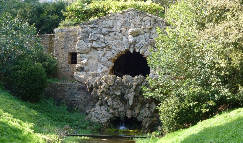
The Grotto
II
Three rough arches of stone with pebble lined basin, c1740 perhaps by
Kent, romanticised and buried c1780. Interior: central vaulted chamber,
with remains of tufa lining, niche in rear wall. Barrel vaulted side chambers
and entrance passages.
Listing NGR: SP6764737501
External links are from the relevant listing authority and, where applicable, Wikidata. Wikidata IDs may be related buildings as well as this specific building. If you want to add or update a link, you will need to do so by editing the Wikidata entry.


Other nearby listed buildings
