Approximate Location Map
Large Map »
Latitude: 51.5164 / 51°30'58"N
Longitude: -2.3021 / 2°18'7"W
OS Eastings: 379132
OS Northings: 179760
OS Grid: ST791797
Mapcode National: GBR 0NV.SXY
Mapcode Global: VH962.14TW
Plus Code: 9C3VGM8X+H5
Entry Name: Barn About 20 Metres South West of Old Warren Farmhouse
Listing Date: 15 August 1985
Grade: II
Source: Historic England
Source ID: 1213234
English Heritage Legacy ID: 397673
ID on this website: 101213234
Location: South Gloucestershire, GL9
County: South Gloucestershire
Civil Parish: Tormarton
Traditional County: Gloucestershire
Lieutenancy Area (Ceremonial County): Gloucestershire
Church of England Parish: Tormarton with West Littleton
Church of England Diocese: Bristol
Tagged with: Barn
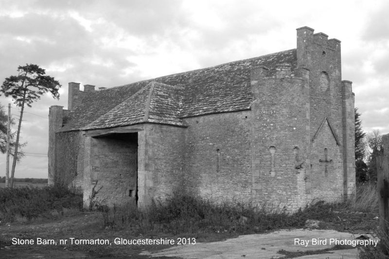
ST 77 NE TORMARTON C.P. ACTON TURVILLE ROAD (south side)
6/231 Barn about 20 metres south west of
Old Warren Farmhouse
- II
Barn. Mid C18, by Thomas Wright (working for 4th Duke of Beaufort at Badminton
1748-56). Coursed rubble with stone dressings and quoins, stone tiled roof.
Gothick style. Central high cart entry with half-hipped roof, mock arrow-slit
with circular ends to each side with ventilation slit open in centre. Right
return has embattled curved corner turrets with blind arrow-slits, raised central
parapet wall with 3 merlons and blind bull's eye at upper level, 3 cross-slits at
ground floor level; single storey gabled attached wing with roof missing at time
of survey (October 1984). Left return as right, with owlhole above oculus.
Rear has cart entry with cambered timber lintel, 2 blocked ventilation slits to
right and one to left, large C20 lean-to addition of no special architectural
interest. Interior: 7-bay roof, principal rafters with plated yokes. 2 rows
of purlins and scissors trusses. Great picturesque landscape value, part of
designed landscape of Beaufort estate in C18. (Sources: Harris, E. : articles
in Country Life, August and 9th September, 1971).
Listing NGR: ST7913279760
External links are from the relevant listing authority and, where applicable, Wikidata. Wikidata IDs may be related buildings as well as this specific building. If you want to add or update a link, you will need to do so by editing the Wikidata entry.


Other nearby listed buildings
